Filter: Categories of Wisconsin Historical Images
Filter: Subject of Aerial photographs
Filter: Subject of cities and towns
Filter: Categories of Wisconsin Historical Images
Filter: Subject of Aerial photographs
Filter: Subject of cities and towns

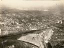
| Date: | 1950 |
|---|---|
| Description: | Aerial view of downtown and river. |

| Date: | |
|---|---|
| Description: | Aerial view of a train crossing the East River in a rural community south of Green Bay. Some buildings are visible to the right and the background of the i... |
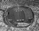
| Date: | 1957 |
|---|---|
| Description: | Aerial view of Lambeau Field (known as City Stadium from 1957 to 1965), home the Green Bay Packers football team, with a full parking lot. The capacity of ... |

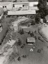
| Date: | 07 24 1952 |
|---|---|
| Description: | Aerial view of the Wisconsin State Fair grounds, showing the GMC trucks tent and the residential neighborhood that bordered the grounds. |
| Date: | |
|---|---|
| Description: | Aerial view of Brodhead Cheese Factory with milk truck on ramp and whey tanks in the center. A boiler room was added later and the factory was moved outwa... |
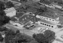
| Date: | 08 1948 |
|---|---|
| Description: | Aerial view of the grounds of the Wisconsin Conservation Department exhibit at the Wisconsin Centennial Exposition. |

| Date: | 1955 |
|---|---|
| Description: | Aerial view of the central traffic loop and Johnson Street expressway. |
| Date: | 1965 |
|---|---|
| Description: | Aerial view of Iola, Wisconsin looking west. Located in the lower left corner is an elementary school. |
| Date: | 1934 |
|---|---|
| Description: | Aerial view of Janesville showing the river fill for the new sewerage disposal plant. |

| Date: | 1957 |
|---|---|
| Description: | Aerial view of Yellowstone Lake and surrounding countryside. |
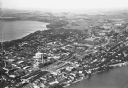
| Date: | |
|---|---|
| Description: | Aerial view looking northeast towards the east side of Madison between Lake Monona and Lake Mendota, from Blair Street to the Yahara River. |
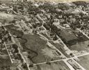
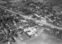
| Date: | 10 1928 |
|---|---|
| Description: | Aerial view of DeForest including residences and the surrounding countryside. |

| Date: | 11 1928 |
|---|---|
| Description: | Aerial view of Verona including businesses, houses, and the surrounding farm land. |
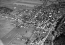
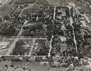
| Date: | 11 1928 |
|---|---|
| Description: | Aerial view of Middleton including businesses, residences, the railroad tracks, and the surrounding countryside. |
| Date: | |
|---|---|
| Description: | Aerial view of downtown Baraboo, including the town square and the Al. Ringling Theater. |
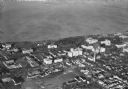
| Date: | 1930 |
|---|---|
| Description: | Aerial view of a portion of the University of Wisconsin-Madison campus and the shoreline of Lake Mendota. |
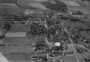
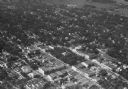
| Date: | 1930 |
|---|---|
| Description: | Aerial view of the town, including business, houses, and railroad tracks cutting through the town. |
If you didn't find the material you searched for, our Library Reference Staff can help.
Call our reference desk at 608-264-6535 or email us at: