Filter: Categories of Wisconsin Historical Images
Filter: Subject of Aerial photographs
Filter: Subject of cities and towns
Filter: Categories of Wisconsin Historical Images
Filter: Subject of Aerial photographs
Filter: Subject of cities and towns
| Date: | 1959 |
|---|---|
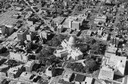
| Description: | Aerial view of the church (built in 1928), the rectory (built in 1876), the school (built in 1958), and the convent (built in 1941). Also includes a view ... |
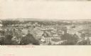
| Date: | 1905 |
|---|---|
| Description: | Caption reads: "Bird's-Eye View, Eau Claire Wis." |
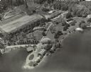
| Date: | 1954 |
|---|---|
| Description: | Aerial view of Kraftwood, the rural estate of the Kraft family of the Kraft Foods Co. of Wisconsin. The estate is situated on a peninsula jutting into Ente... |

| Date: | 1965 |
|---|---|
| Description: | Aerial view of town and Highway 66. |

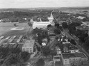
| Date: | 1922 |
|---|---|
| Description: | Aerial view of the Wisconsin State Capitol and Lake Monona. |

| Date: | 1957 |
|---|---|
| Description: | Aerial view of the north corner of Capitol Square looking toward Lake Mendota. The Belmont Hotel is featured prominently. |

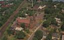
| Date: | |
|---|---|
| Description: | Aerial view looking southwest over the University of Wisconsin-Madison Stock Pavilion barns. |
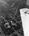
| Date: | 1954 |
|---|---|
| Description: | Aerial view of the Wisconsin State Capitol, including a bit of the airplane wing. |

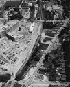
| Date: | 1956 |
|---|---|
| Description: | Aerial view of the new Madison television facility, WISC-TV (Channel 3), showing the transmitting tower in construction. The location is to the southwest,... |

| Date: | 01 1946 |
|---|---|
| Description: | Aerial view of the Lake Mendota shoreline during the construction of the Edgewater Hotel. It is a view looking west over the junction of Langdon Street an... |
| Date: | 1954 |
|---|---|
| Description: | An air view of Madison including the Veterans Hospital, Forest Products Laboratory and University Avenue from Farley (lower edge), to Allen Streets. |

| Date: | 1934 |
|---|---|
| Description: | Aerial view of Capitol and Lake Mendota and Lake Monona. |

| Date: | 1928 |
|---|---|
| Description: | Aerial view of Madison looking southeast over the isthmus, showing the Four Lakes Country. Visible at the bottom is the Lake Mendota shoreline. At center, ... |

| Date: | 1948 |
|---|---|
| Description: | Aerial view of the Wisconsin State Capitol and surrounding area looking south southeast towards Lake Monona. |
| Date: | 1945 |
|---|---|
| Description: | Aerial view of Madison over the University Avenue-Randall Stadium area, looking toward the Congregationalist Church and the U.S. Forest Products Laboratory... |

| Date: | 1956 |
|---|---|
| Description: | Aerial view looking northeast from a point over the east end of Middleton, showing the west end of Lake Mendota (right mid-ground). Fox Bluff juts into the... |

| Date: | 1955 |
|---|---|
| Description: | An air view of Madison's downtown area with the Wisconsin State Capitol and new State Office Buildings. |
If you didn't find the material you searched for, our Library Reference Staff can help.
Call our reference desk at 608-264-6535 or email us at: