 Filter: Categories of Wisconsin Historical Images
Filter: Subject of Aerial photographs
Filter: Subject of central business districts
Filter: Categories of Wisconsin Historical Images
Filter: Subject of Aerial photographs
Filter: Subject of central business districts

| Date: | 1928 |
|---|---|
| Description: | Aerial view of the Wisconsin State Capitol, looking northeast. The Park Hotel on the corner of W. Main Street and S. Carroll Street, is in the foreground. |

| Date: | 1950 |
|---|---|
| Description: | Aerial view of the Wisconsin State Capitol building and surrounding Madison area. Lake Monona is in the background. |

| Date: | 1958 |
|---|---|
| Description: | Aerial view of the Wisconsin State Capitol and surrounding area. The view is looking northwest, with King Street on the bottom right, and S. Hamilton Stree... |
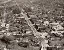
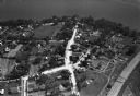
| Date: | 1950 |
|---|---|
| Description: | Aerial view of the main street of town. |

| Date: | 1931 |
|---|---|
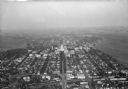
| Description: | Aerial view looking north, with a small portion of the West Side (left), nearly all of the North Side and part of the business district of the East Side. A... |

| Date: | 1953 |
|---|---|
| Description: | Aerial view looking southeast over Madison's near east side. The Eagles Club at 1236 Jenifer Street / 1221 Williamson Street is under construction in the ... |

| Date: | 1955 |
|---|---|
| Description: | Aerial view of the central traffic loop and Johnson Street expressway. |

| Date: | 1955 |
|---|---|
| Description: | Aerial view of the Illinois central route. The UW Fieldhouse is visible in the lower right of the image. |
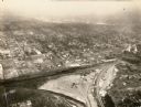
| Date: | 1934 |
|---|---|
| Description: | Aerial view of Janesville showing the river fill for the new sewerage disposal plant. |

| Date: | 11 1928 |
|---|---|
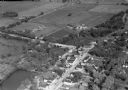
| Description: | Aerial view of Verona including businesses, houses, and the surrounding farm land. |
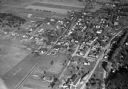
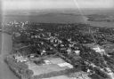
| Date: | 11 1928 |
|---|---|
| Description: | Aerial view of Middleton including businesses, residences, the railroad tracks, and the surrounding countryside. |
| Date: | |
|---|---|
| Description: | Aerial view of downtown Baraboo, including the town square and the Al. Ringling Theater. |
| Date: | 1930 |
|---|---|
| Description: | Aerial view looking southeast, towards the city, including the Wisconsin State Capitol, the central business district, the Capitol Square, both Lake Mendot... |
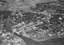
| Date: | 11 1928 |
|---|---|
| Description: | Aerial view of Stoughton including the central business district, the Yahara River, and the surrounding countryside. |
| Date: | 1930 |
|---|---|
| Description: | Aerial view of the Isthmus and the city of Madison including the downtown business district, the Wisconsin State Capitol, both Lake Mendota and Lake Monona... |
| Date: | |
|---|---|
| Description: | Aerial view of the town, including the Wisconsin River, and the surrounding countryside. |
| Date: | 10 1928 |
|---|---|
| Description: | Aerial view of Belleville, including the central business disctrict and the surrounding countryside. |
| Date: | 1930 |
|---|---|
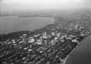
| Description: | Aerial view of the city and the Isthmus, the Wisconsin State Capitol, the downtown business district, and both Lake Mendota and Lake Monona. |
| Date: | 1930 |
|---|---|
| Description: | Aerial view of the city, including the Isthmus, the Wisconsin State Capitol, the downtown business district, Lake Mendota, and Lake Monona. |

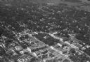
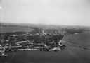
| Date: | 10 1928 |
|---|---|
| Description: | Aerial view of Sun Prairie, including the central business district, residences, and the surrounding countryside stretching to the horizon. |
If you didn't find the material you searched for, our Library Reference Staff can help.
Call our reference desk at 608-264-6535 or email us at: