Filter: Categories of Wisconsin Historical Images
Filter: Subject of Aerial photographs
Filter: Subject of botany
Filter: Categories of Wisconsin Historical Images
Filter: Subject of Aerial photographs
Filter: Subject of botany
| Date: | 04 21 1949 |
|---|---|
| Description: | Taliesin, the home of Frank Lloyd Wright near Spring Green. Taliesin is located in the vicinity of Spring Green, Wisconsin. |
| Date: | 04 27 1949 |
|---|---|
| Description: | Aerial view of New Lisbon. |

| Date: | 07 12 1949 |
|---|---|
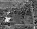
| Description: | Aerial view of the residence of Mrs. George M. Fisk, 325 Lakewood Blvd., and other homes along the shore of Lake Mendota in Maple Bluff. Ida Johnson Fisk, ... |
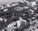
| Date: | 1959 |
|---|---|
| Description: | Aerial view over University Avenue of University of Wisconsin-Madison campus. Chadbourne Hall, built 1958-1959, is in the lower foreground, the Wisconsin H... |
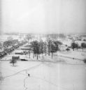
| Date: | 1939 |
|---|---|
| Description: | Elevated winter scene of Greendale (Milwaukee Co.), Wisconsin. Housing, roads and trees are visible in the distance. One person is walking through the snow... |
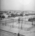
| Date: | 1939 |
|---|---|
| Description: | Elevated view of village with snow on the ground. A tennis court, flag pole, and pedestrians are visible in the foreground. Behind the tennis court are roa... |

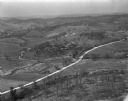
| Date: | 04 23 1970 |
|---|---|
| Description: | Aerial view of the farm grounds that would be the site of the Sound Storm music festival. |
| Date: | |
|---|---|
| Description: | Aerial view of the Prairie du Chien plant of Oscar Mayer & Co. |

| Date: | 1925 |
|---|---|
| Description: | Aerial view of the site of the Confederate surrender in 1865. |
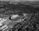
| Date: | 05 11 1951 |
|---|---|
| Description: | Aerial view of Camp Randall Stadium and Fieldhouse looking south. The photograph was taken during a ROTC annual inspection. |
| Date: | |
|---|---|
| Description: | The Villa Louis, also known as Dousman Mansion, in an aerial view. |

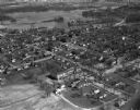
| Date: | 1955 |
|---|---|
| Description: | Aerial view of Schenk's Corners where Atwood Avenue and Winnebago Street cross, looking north west toward East Washington Avenue. ... |

| Date: | 1956 |
|---|---|
| Description: | Aerial view of Schenk's Corners where Atwood Avenue and Winnebago Street cross, looking north east. |

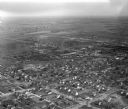
| Date: | 04 17 1952 |
|---|---|
| Description: | Aerial view of Madison taken from near the site of the WIBA radio tower, looking east toward the isthmus. Other images in this set look to the northwest, s... |

| Date: | 04 17 1952 |
|---|---|
| Description: | Aerial view of Madison looking toward the capitol building from over East Washington Avenue and Commercial Avenue. Other images in this set look toward the... |
| Date: | |
|---|---|
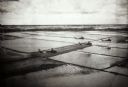
| Description: | Elevated view of helicopters flying over rice fields in Vietnam. |
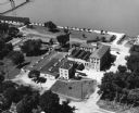
| Date: | 1950 |
|---|---|
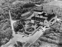
| Description: | An aerial view of the monastery, showing a complex of buildings, roads, and the surrounding tree-covered property. A walled garden is between the entrance ... |
If you didn't find the material you searched for, our Library Reference Staff can help.
Call our reference desk at 608-264-6535 or email us at: