 Filter: Categories of Wisconsin Historical Images
Filter: Subject of Aerial photographs
Filter: Subject of botany
Filter: Categories of Wisconsin Historical Images
Filter: Subject of Aerial photographs
Filter: Subject of botany

| Date: | |
|---|---|
| Description: | Aerial view of Wisconsin State Capitol. |

| Date: | 02 06 1948 |
|---|---|
| Description: | Aerial photograph of Madison's west side looking northeast along Speedway Road. Visible are Forest Hill and Resurrection Cemeteries, West High School, Hoyt... |

| Date: | 02 06 1948 |
|---|---|
| Description: | Aerial view of west side, looking south along Glenway Street. Visible are the reservoir, Lake Wingra, Forest Hill and Resurrection Cemetery, Hoyt Park. Maj... |

| Date: | 02 06 1948 |
|---|---|
| Description: | Aerial photograph looking northwest across the reservoir on Glenway Street. Featured are Hoyt and Quarry Parks, Resurrection Cemetery. Major streets are Fr... |

| Date: | 02 06 1948 |
|---|---|
| Description: | Looking north along Glenway Street. Visible are the reservoir, Hoyt and Quarry Parks, Resurrection and Forest Hill Cemeteries, Rentschler Greenhouses, Fore... |

| Date: | 02 06 1948 |
|---|---|
| Description: | Looking southeast across Speedway Road. Visible are the reservoir on Glenway Street, Hoyt Park, Resurrection and Forest Hill cemeteries, Glenway Golf cours... |

| Date: | 02 06 1948 |
|---|---|
| Description: | Looking east along Regent Street with snow on the ground. Visible are Lake Wingra, Monona Bay, railroad causeway across Monona, Lake Mendota, Hoyt Park, We... |

| Date: | 06 05 1951 |
|---|---|
| Description: | Aerial view of the Sherman Terrace Apartments and surrounding area. |
| Date: | 09 1958 |
|---|---|
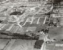
| Description: | Aerial view of University Farms neighborhood near Lake Mendota. |
| Date: | 09 1958 |
|---|---|
| Description: | University Hill Farms from an aerial perspective. |

| Date: | 1910 |
|---|---|
| Description: | Aerial view looking toward Lake Wingra. In the foreground is the Yawkey-Crowley Lumber Yard. The company built it's warehouse at 1542 Monroe Street between... |

| Date: | 1940 |
|---|---|
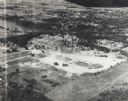
| Description: | Aerial view of the college. Several buildings make up the college, surrounded by paths, roads, fields and trees. Caption reads: "Mount Mary College." |
| Date: | 1955 |
|---|---|
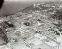
| Description: | Aerial view of Valley Fair Mall, with a residential area beyond it on both sides of a river, all surrounded by trees and farmland. |

| Date: | 1947 |
|---|---|
| Description: | University of Wisconsin-Madison, from Park Street to the men's dormitories. Part of Lake Mendota is in the top right corner. |

| Date: | 1946 |
|---|---|
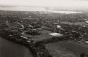
| Description: | University of Wisconsin-Madison buildings. The General Hospital is in the center, surrounded by homes, trees, and other university buildings. |

| Date: | 1946 |
|---|---|
| Description: | University of Wisconsin-Madison campus on isthmus, including the Agricultural campus and men's dormitories. Part of Lake Mendota is in the top right corner... |
| Date: | 1946 |
|---|---|
| Description: | View towards southeast of the University of Wisconsin-Madison on isthmus. Lake Mendota is in the lower left corner, and Lake Monona is in the upper portion... |
| Date: | 1924 |
|---|---|
| Description: | University of Wisconsin-Madison aerial view overlooking the lower campus and surrounding neighborhoods. Lake Mendota and Picnic Point are in the background... |

| Date: | 1946 |
|---|---|
| Description: | University of Wisconsin-Madison campus, looking south from Lake Mendota. Camp Randall stadium is in the upper right. |

| Date: | 1928 |
|---|---|
| Description: | University of Wisconsin-Madison, looking west. Lake Mendota and Picnic Point are in the upper right of the image. Bascom Hall, the Red Gym, the Wisconsin H... |
If you didn't find the material you searched for, our Library Reference Staff can help.
Call our reference desk at 608-264-6535 or email us at: