Filter: Categories of Wisconsin Historical Images
Filter: Subject of Aerial photographs
Filter: Subject of boats and boating
Filter: Categories of Wisconsin Historical Images
Filter: Subject of Aerial photographs
Filter: Subject of boats and boating
| Date: | 1903 |
|---|---|
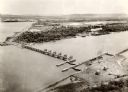
| Description: | Aerial view of the Green Bay harbor area. |

| Date: | 1964 |
|---|---|
| Description: | Marshfield Airways, covered with snow. A river full of ice and snow, with boats along the shoreline, is in the lower portion of the image. |

| Date: | 1953 |
|---|---|
| Description: | Aerial view looking north from the foot of Milwaukee's main thoroughfare, Wisconsin Avenue. Lincoln Memorial Drive winds its way along the lagoon in Juneau... |

| Date: | |
|---|---|
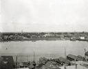
| Description: | An aerial view of the port and a section of the city showing a large boat, a railway depot, a park plaza and a grid of city streets with large buildings. |
| Date: | |
|---|---|
| Description: | Aerial view of a harbor with a wharf in the foreground, and buildings and boathouses along the shoreline. |

| Date: | |
|---|---|
| Description: | Aerial view of a developed strip of land on Barnegat Bay showing the Atlantic ocean, houses, lakes, railroad tracks, a marina and a jetty in the distance. |

| Date: | |
|---|---|
| Description: | Bird's eye view of Coney Island featuring the amusement park, shoreline, river, and a large boat. |

| Date: | |
|---|---|
| Description: | Color postcard of an aerial view of the Lakewoods Family Resort on Lake Namekagon. All modern housekeeping cottages with an indoor heated swimming pool. |
| Date: | 1982 |
|---|---|
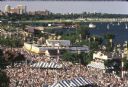
| Description: | Bird's-eye view of a large crowd of music fans gathered at Summerfest, looking northeast toward the current site of Discovery World. Sailboats are on Lake ... |
| Date: | |
|---|---|
| Description: | The world is flat; we get around this stretched credulity by going straight as an arrow and meeting ourselves in a space of time |

| Date: | |
|---|---|
| Description: | Aerial view of Vieth's Park subdivision on the north shore of Lake Mendota. |

| Date: | |
|---|---|
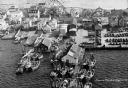
| Description: | Aerial photograph of the Port of Kenosha and factories, with snow on the ground. There are four ships along the shoreline, and multiple factories on either... |

| Date: | 06 14 1961 |
|---|---|
| Description: | Aerial view of North and South Harbor Tracts, looking north from South Pier No. 2. There are skyscrapers in the background. there are multiple items of mac... |

| Date: | |
|---|---|
| Description: | Aerial view of harbors and bridge. Farm fields are on either side of the bridge. The city of Sturgeon Bay is in the distance. There are docks along the sho... |

| Date: | |
|---|---|
| Description: | Aerial view of harbor. In the foreground is a lighthouse and breakwaters. Bridges cross the harbor, and there are factory and industrial buildings near the... |

| Date: | |
|---|---|
| Description: | Aerial view of Ephraim and Eagle Bay. A two-lane highway runs along the coastline. Caption reads: "Ephraim, Wisconsin." |

| Date: | 1905 |
|---|---|
| Description: | Aerial view of Fountain City and the Mississippi River. Caption reads: "Fountain City, Wis." |
If you didn't find the material you searched for, our Library Reference Staff can help.
Call our reference desk at 608-264-6535 or email us at: