 Filter: Categories of Wisconsin Historical Images
Filter: Subject of Aerial photographs
Filter: Subject of boathouses
Filter: Categories of Wisconsin Historical Images
Filter: Subject of Aerial photographs
Filter: Subject of boathouses
| Date: | |
|---|---|
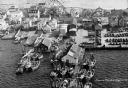
| Description: | Aerial view of a harbor with a wharf in the foreground, and buildings and boathouses along the shoreline. |

| Date: | |
|---|---|
| Description: | Aerial view of a developed strip of land on Barnegat Bay showing the Atlantic ocean, houses, lakes, railroad tracks, a marina and a jetty in the distance. |
| Date: | 1937 |
|---|---|
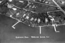
| Description: | Aerial view of Nebraska Row on the lakeshore of the west side of La Pointe, showing houses, roads and piers. Nebraska Row was started in 1899 when summer r... |

| Date: | 06 14 1961 |
|---|---|
| Description: | Aerial view of North and South Harbor Tracts, looking north from South Pier No. 2. There are skyscrapers in the background. there are multiple items of mac... |

| Date: | |
|---|---|
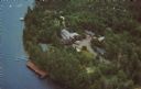
| Description: | Aerial view of the cow palace and pasture, the boathouse, and the Lake Namakagon shoreline. The main lodge is barely visible among trees. Old highway count... |
| Date: | 1950 |
|---|---|
| Description: | Text on reverse reads: "Froelich's Sayner Lodge, Sayner, Wisconsin. AAA. One of Northern Wisconsin's fine American Plan Resorts * Your choice of accommodat... |
If you didn't find the material you searched for, our Library Reference Staff can help.
Call our reference desk at 608-264-6535 or email us at: