Filter: Categories of Wisconsin Historical Images
Filter: Subject of Aerial photographs
Filter: Subject of automobiles
Filter: Categories of Wisconsin Historical Images
Filter: Subject of Aerial photographs
Filter: Subject of automobiles

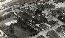
| Date: | 1956 |
|---|---|
| Description: | Aerial view of the Chicago, Milwaukee, and St. Paul Railroad station, roundhouse, and yard at the intersection of West Washington Avenue (across lower left... |
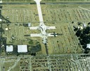
| Date: | 1988 |
|---|---|
| Description: | Aerial view of the 1988 EAA (Experimental Aviation Association) Convention and Fly-in at Wittman Field. On the ground is the Concorde and a B-1 Bomber. |
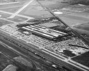
| Date: | 02 02 1954 |
|---|---|
| Description: | Aerial view of International Harvester's Evansville Works factory complex. The Evansville Works produced refrigerators, freezers and air conditioners. |
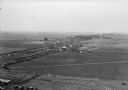
| Date: | 1930 |
|---|---|
| Description: | Aerial view of airplane races at the Janesville airport, including airplanes on the landing field, airport structures, cars parked around the airport, and ... |

| Date: | |
|---|---|
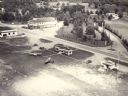
| Description: | Aerial view of a crowd at the Pennco Field (Royal Airport), gathered for an aerial show. Biplanes possibly used for the show are on the airstrip. Automob... |

| Date: | 1930 |
|---|---|
| Description: | Aerial view of the Pennco Field (Royal Airport) hanger surrounded by spectators gathered for an air show. Biplanes are parked on the grounds of the airpor... |
| Date: | 1933 |
|---|---|
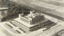
| Description: | Aerial view of the Forest Products Laboratory, built in 1932. |
| Date: | 1957 |
|---|---|
| Description: | Aerial view of the Baraboo Wisconsin Dells airport. |

| Date: | |
|---|---|
| Description: | Aerial view of a full Camp Randall Stadium during half-time of a football game. The band is on the field in formation to spell "UW." |
| Date: | 1955 |
|---|---|
| Description: | Aerial view of town, with commercial buildings, and cars in parking lots. |

| Date: | 1960 |
|---|---|
| Description: | Aerial view of the construction of the interstate highway near Mirror Lake, showing only the early stages of the bridge construction. |

| Date: | 11 1951 |
|---|---|
| Description: | Aerial view of US Highway 14 southeast of La Crosse descending into Mormon Coulee. The original caption of the print, which is undated, describes the road ... |

| Date: | 1947 |
|---|---|
| Description: | Aerial view of Monroe. A large building with a clock tower, commercial buildings, parking lots and automobiles can be seen. |

| Date: | 05 05 1947 |
|---|---|
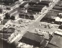
| Description: | Aerial view of the intersection of Pinckney, Main, and King Streets on the Madison Capitol Square. Kresge's, 27 East Main Street, can be seen at the upper ... |

| Date: | 05 05 1947 |
|---|---|
| Description: | Aerial view of Main, King, and Pinckney Streets intersection on Madison's Capitol Square. View is looking south down Pinckney Street. Kresge's, 27 East Mai... |

| Date: | 1956 |
|---|---|
| Description: | Aerial view of the Sears-Roebuck department store on East Washington Avenue and its surrounding parking lots. |

| Date: | 06 05 1951 |
|---|---|
| Description: | Aerial view of the Sherman Terrace Apartments and surrounding area. |

| Date: | 1958 |
|---|---|
| Description: | An aerial view of the construction of a new wing on a state office building. Automobiles are parked in a log along Lake Monona. |

| Date: | 1947 |
|---|---|
| Description: | City Hall near the Milwaukee River. |
If you didn't find the material you searched for, our Library Reference Staff can help.
Call our reference desk at 608-264-6535 or email us at: