 Filter: Categories of Wisconsin Historical Images
Filter: Subject of Aerial photographs
Filter: County of Milwaukee
Filter: Subject of transportation
Filter: Categories of Wisconsin Historical Images
Filter: Subject of Aerial photographs
Filter: County of Milwaukee
Filter: Subject of transportation

| Date: | 1964 |
|---|---|
| Description: | Aerial view of the Milwaukee County Zoo grounds nearing its completion. |
| Date: | |
|---|---|
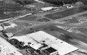
| Description: | An aerial view of the Milwaukee County Airport. The office, also seen in Image ID: 11454 is visible in the lower left corner. |
| Date: | |
|---|---|
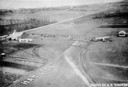
| Description: | The airfield of the Hamilton Aero Manufacturing Company which became the site of Milwaukee County Airport in 1926. It was established by Thomas Hamilton, a... |

| Date: | 11 16 2001 |
|---|---|
| Description: | Aerial view of General Mitchell International in Milwaukee, looking southeast to the Lake Michigan shoreline. |
| Date: | 03 09 1965 |
|---|---|
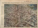
| Description: | Aerial view and illustration of projected projects, including interstates and interchanges in downtown Milwaukee, for the 1970's. |

| Date: | 07 24 1952 |
|---|---|
| Description: | Aerial view of the Wisconsin State Fair grounds, showing the GMC trucks tent and the residential neighborhood that bordered the grounds. |
| Date: | 1935 |
|---|---|
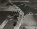
| Description: | Aerial view of the paving operation of Joseph D. Bonners, Inc., on St. Martins Road at Hales Corners. |

| Date: | 1975 |
|---|---|
| Description: | Aerial view of Milwaukee County Stadium and the intersection of US 41 and I-94. County Stadium was built in 1953 and demolished in 2001. Although undated... |

| Date: | 1965 |
|---|---|
| Description: | Aerial view of early construction at the Marquette Interchange in Milwaukee, the junction of Interstate Highways I94 and I43. Construction began in 1964, ... |

| Date: | |
|---|---|
| Description: | Aerial view of the first Marquette Interchange, photographed some time after its completion in 1968. |

| Date: | 04 01 1975 |
|---|---|
| Description: | The bridge over the Milwaukee Harbor named in honor of former Mayor Daniel Hoan. The bridge was constructed between 1970 and 1972, but during the period de... |

| Date: | |
|---|---|
| Description: | Elevated view looking northeast from the roof of the Wells Building at E. Wisconsin Avenue and N. Milwaukee Street. St. John's Cathedral is in the center o... |

| Date: | 1955 |
|---|---|
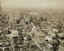
| Description: | Aerial view of downtown, including railroad tracks in foreground. |

| Date: | 1951 |
|---|---|
| Description: | Aerial view of Jones Island and garbage disposal plant. |

| Date: | 1950 |
|---|---|
| Description: | Harbor area of Jones Island and garbage disposal plant, Stratton Grain Co., and more. |

| Date: | 1950 |
|---|---|
| Description: | Divided highway is South Chase Avenue between West Lincoln Avenue (2300) and East Oklahoma Avenue (3100). |
| Date: | |
|---|---|
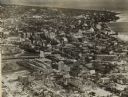
| Description: | Aerial view looking north of downtown, with the Milwaukee River and Lake Michigan. |
| Date: | 1930 |
|---|---|
| Description: | Aerial view of downtown area including churches, homes, and large buildings, stretching to the horizon. |
| Date: | 1938 |
|---|---|
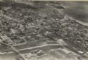
| Description: | Aerial view of rivers, with Lake Michigan in upper right, train yards, and highway in lower left. |

| Date: | 1922 |
|---|---|
| Description: | Aerial view of downtown with City Hall and Milwaukee River. |
If you didn't find the material you searched for, our Library Reference Staff can help.
Call our reference desk at 608-264-6535 or email us at: