 Filter: Categories of Wisconsin Historical Images
Filter: Subject of Aerial photographs
Filter: County of Dane
Filter: Categories of Wisconsin Historical Images
Filter: Subject of Aerial photographs
Filter: County of Dane

| Date: | 1955 |
|---|---|
| Description: | Aerial view of Atwood Avenue, looking west towards Winnebago Street and "Schenk's Corners." |

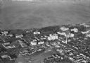
| Date: | 1930 |
|---|---|
| Description: | Aerial view of isthmus looking east toward Lake Mendota and the Wisconsin State Capitol, with Lake Monona and the horizon in the background. |

| Date: | 07 06 1937 |
|---|---|
| Description: | Aerial view of the west central part of isthmus and the University of Wisconsin campus. |
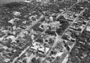
| Date: | 1928 |
|---|---|
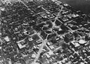
| Description: | Aerial view of Capitol Square and vicinity, looking east-northeast. State Street is visible at the bottom center. |
| Date: | 1919 |
|---|---|
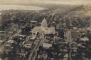
| Description: | Aerial view of the Capitol Square and surrounding area. Lake Monona and Lake Wingra are in the background. |

| Date: | |
|---|---|
| Description: | Aerial view over the Wisconsin State Capitol looking south south-east. |

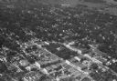
| Date: | 1953 |
|---|---|
| Description: | Aerial view looking southeast over Madison's near east side. The Eagles Club at 1236 Jenifer Street / 1221 Williamson Street is under construction in the ... |

| Date: | 1955 |
|---|---|
| Description: | Aerial view of the central traffic loop and Johnson Street expressway. |

| Date: | 1955 |
|---|---|
| Description: | Aerial view of the Illinois central route. The UW Fieldhouse is visible in the lower right of the image. |
| Date: | |
|---|---|
| Description: | Aerial view looking northeast towards the east side of Madison between Lake Monona and Lake Mendota, from Blair Street to the Yahara River. |
| Date: | 1930 |
|---|---|
| Description: | Aerial view of Turville Point and Turville farm, Lake Monona. |
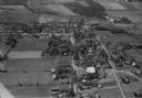
| Date: | 10 1928 |
|---|---|
| Description: | Aerial view of DeForest including residences and the surrounding countryside. |
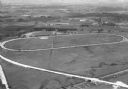
| Date: | 1930 |
|---|---|
| Description: | Aerial view of the Dane County fairgrounds, including several buildings and a track. |
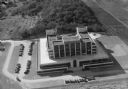
| Date: | 1930 |
|---|---|
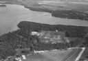
| Description: | Aerial view of the Forest Products Laboratory, 1 Gifford Pinchot Drive. |

| Date: | 11 1928 |
|---|---|
| Description: | Aerial view of Verona including businesses, houses, and the surrounding farm land. |
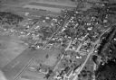
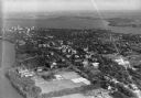
| Date: | 11 1928 |
|---|---|
| Description: | Aerial view of Middleton including businesses, residences, the railroad tracks, and the surrounding countryside. |
| Date: | |
|---|---|
| Description: | Aerial view of downtown Baraboo, including the town square and the Al. Ringling Theater. |
| Date: | 1930 |
|---|---|
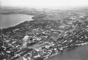
| Description: | Aerial view of a portion of the University of Wisconsin-Madison campus and the shoreline of Lake Mendota. |
| Date: | 1930 |
|---|---|
| Description: | Aerial view looking southeast, towards the city, including the Wisconsin State Capitol, the central business district, the Capitol Square, both Lake Mendot... |
| Date: | |
|---|---|
| Description: | Aerial view of downtown area featuring the Wisconsin State Capitol. |
If you didn't find the material you searched for, our Library Reference Staff can help.
Call our reference desk at 608-264-6535 or email us at: