 Filter: Categories of Wisconsin Historical Images
Filter: Subject of Aerial photographs
Filter: County of Dane
Filter: Categories of Wisconsin Historical Images
Filter: Subject of Aerial photographs
Filter: County of Dane

| Date: | 12 22 1953 |
|---|---|
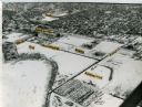
| Description: | Aerial photograph of Crawford Heights looking west along the West Beltline. The photograph shows Nakoma Road, Midvale Boulevard, Cherokee School, and the A... |

| Date: | 12 23 1953 |
|---|---|
| Description: | Aerial view of Crawford Heights looking west along the West Beltline. The photograph shows Nakoma Road, Midvale Boulevard, Cherokee School, and the Arboret... |

| Date: | 12 23 1953 |
|---|---|
| Description: | Aerial view of Crawford Heights looking north by northwest along the West Beltline with Cherokee School and the Arboretum at lower right and Lake Mendota a... |
| Date: | 1965 |
|---|---|
| Description: | Aerial view of the UW-Madison campus near University Bay in winter. Labels are pasted to the print to indicate Elm Dr., the gym, Camp Randall Stadium, the ... |
| Date: | 1958 |
|---|---|
| Description: | Aerial view of Kapec Orchards on Verona Road between McKee and Nesbitt Roads. |

| Date: | 07 14 1958 |
|---|---|
| Description: | This is a Tellurometer, a microwave surveying instrument. The operator is Don Reed, field man for Alster and Associates, Washington, D.C., which completed ... |

| Date: | |
|---|---|
| Description: | An aerial view of Governor's Island. A cutout of an arrow has been added. |

| Date: | 1959 |
|---|---|
| Description: | Aerial view of the Westgate Shopping Center under construction. |

| Date: | 1955 |
|---|---|
| Description: | Aerial view, looking west from over Hoyt Park toward Midvale Boulevard. |

| Date: | |
|---|---|
| Description: | Aerial view of Vieth's Park subdivision on the north shore of Lake Mendota. |

| Date: | 1954 |
|---|---|
| Description: | Aerial view of the west side of Madison showing newly constructed homes and homes under construction featured in the Parade of Homes. The main road through... |

| Date: | 12 23 1954 |
|---|---|
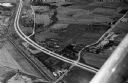
| Description: | Aerial view of the intersection of the West Beltline Highway and Verona Road (Highways 18-151). Includes Vikingtown Motel, town of Madison hall, Ballweg's ... |

| Date: | 01 15 1964 |
|---|---|
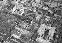
| Description: | Aerial photograph of the intersection of Mifflin, Pinckney, and Hamilton streets on Madison's Capitol Square. The Madison Hotel, 108 North Pinckney Street,... |

| Date: | 01 31 1964 |
|---|---|
| Description: | Aerial view of University Hill Farms area which has grown from a cow pasture to a square-mile housing and business area. 4,000 people live in 750 single-fa... |

| Date: | 03 28 1959 |
|---|---|
| Description: | Elevated view of a parking lot along John Nolen Drive on the shore of a partially frozen Lake Monona. Railroad tracks are in the foreground on the right. |
| Date: | |
|---|---|
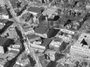
| Description: | Aerial view of Madison, including the Capitol Square on the left at Mifflin and State Street, and Central High School, the light-colored building in the fo... |

| Date: | |
|---|---|
| Description: | Aerial view of the Capitol Square, with Capitol Park and part of the Wisconsin State Capitol. Manchester's is on the corner of Mifflin Street at Wisconsin ... |
| Date: | |
|---|---|
| Description: | Aerial view of Madison, including Yost's, State Street, The Orpheum Theatre, Hills, the Madison Public Library, block 64 parking, East Johnson Street, and ... |

| Date: | |
|---|---|
| Description: | Aerial view of Madison featuring Central High School/Madison Area Technical College (MATC) at top center. |

| Date: | 1919 |
|---|---|
| Description: | Aerial view looking north over Lake Monona towards the Wisconsin State Capitol on the isthmus. Lake Mendota is in the background. |
If you didn't find the material you searched for, our Library Reference Staff can help.
Call our reference desk at 608-264-6535 or email us at: