Filter: Categories of Wisconsin Historical Images
Filter: Subject of Aerial photographs
Filter: County of Dane
Filter: Year of 1900-1999
Filter: Year of 1940-1949
Filter: Categories of Wisconsin Historical Images
Filter: Subject of Aerial photographs
Filter: County of Dane
Filter: Year of 1900-1999
Filter: Year of 1940-1949

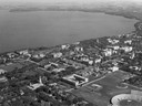
| Date: | 1940 |
|---|---|
| Description: | Aerial view looking east over the center of the city and the University of Wisconsin-Madison campus. |
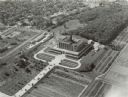
| Date: | 1948 |
|---|---|
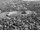
| Description: | Aerial view of Camp Randall Stadium and Field House. |

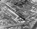
| Date: | 1942 |
|---|---|
| Description: | Aerial view of Oscar Mayer & Company, 910 Mayer Avenue at Packers Avenue. Shows stock yards, railroad cars and automobile parking lot. Also shows C.E. & P.... |

| Date: | 1945 |
|---|---|
| Description: | View of the lower campus of the University of Wisconsin-Madison includes Bascom Hill, Wisconsin Historical Society, Memorial Union and the Armory (Red Gym ... |

| Date: | 1945 |
|---|---|
| Description: | Aerial view of Bascom Hill, Bascom Hall, Wisconsin Historical Society on the University of Wisconsin Madison campus with Lake Mendota on the right. |
| Date: | 1946 |
|---|---|
| Description: | Aerial view of the University of Wisconsin campus with Lake Mendota on the right. |
| Date: | 1948 |
|---|---|
| Description: | Aerial view of Camp Randall Stadium and Field House looking north on the University of Wisconsin-Madison campus with Lake Mendota in the background. |
| Date: | 1947 |
|---|---|
| Description: | Aerial of University of Wisconsin-Madison campus with Camp Randall in the lower right corner and Lake Mendota, looking northeast to Maple Bluff. |

| Date: | 1946 |
|---|---|
| Description: | Aerial view of University of Wisconsin-Madison campus with Bascom Hill area, Observatory Drive and Lake Mendota. |
| Date: | 10 18 1945 |
|---|---|
| Description: | Madison Ray-O-Vac plant, 2313-25 Winnebago Street. |

| Date: | 01 1946 |
|---|---|
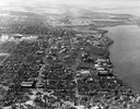
| Description: | Aerial view of the Lake Mendota shoreline during the construction of the Edgewater Hotel. It is a view looking west over the junction of Langdon Street an... |

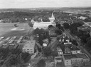
| Date: | 1948 |
|---|---|
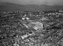
| Description: | Aerial view of the Wisconsin State Capitol and surrounding area looking south southeast towards Lake Monona. |
| Date: | 1945 |
|---|---|
| Description: | Aerial view of Madison over the University Avenue-Randall Stadium area, looking toward the Congregationalist Church and the U.S. Forest Products Laboratory... |
| Date: | 1946 |
|---|---|
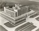
| Description: | An aerial view of the U.S. Forest Products Laboratory. |

| Date: | 1947 |
|---|---|
| Description: | Aerial view of the Forest Products Laboratory. |

| Date: | 1947 |
|---|---|
| Description: | Aerial view of one hundred ninety government surplus trailers, parked near Camp Randall, provided temporary housing for World War II veterans and their fam... |

| Date: | 05 05 1947 |
|---|---|
| Description: | Aerial view of the intersection of Pinckney, Main, and King Streets on the Madison Capitol Square. Kresge's, 27 East Main Street, can be seen at the upper ... |

| Date: | 05 05 1947 |
|---|---|
| Description: | Aerial view of Main, King, and Pinckney Streets intersection on Madison's Capitol Square. View is looking south down Pinckney Street. Kresge's, 27 East Mai... |

| Date: | 05 08 1947 |
|---|---|
| Description: | Aerial view of the Forsberg Paper Box Company, 2107 Fordem Avenue. View looks to the northeast toward Oscar Mayer. |
If you didn't find the material you searched for, our Library Reference Staff can help.
Call our reference desk at 608-264-6535 or email us at: