 Filter: Categories of Wisconsin Historical Images
Filter: Subject of Aerial photographs
Filter: County of Dane
Filter: Year of 1900-1999
Filter: Categories of Wisconsin Historical Images
Filter: Subject of Aerial photographs
Filter: County of Dane
Filter: Year of 1900-1999

| Date: | 05 05 1947 |
|---|---|
| Description: | Aerial view of Main, King, and Pinckney Streets intersection on Madison's Capitol Square. View is looking south down Pinckney Street. Kresge's, 27 East Mai... |

| Date: | 05 08 1947 |
|---|---|
| Description: | Aerial view of the Forsberg Paper Box Company, 2107 Fordem Avenue. View looks to the northeast toward Oscar Mayer. |

| Date: | 05 08 1947 |
|---|---|
| Description: | Aerial photograph of the Capitol Square area of Madison, looking to the southwest. |

| Date: | 10 10 1947 |
|---|---|
| Description: | Aerial view of the Wisconsin Memorial Hospital run by the Veterans Administration on the north shore of Lake Mendota on the grounds of the Mendota State Ho... |

| Date: | 02 06 1948 |
|---|---|
| Description: | Aerial photograph of Madison's west side looking northeast along Speedway Road. Visible are Forest Hill and Resurrection Cemeteries, West High School, Hoyt... |

| Date: | 02 06 1948 |
|---|---|
| Description: | Aerial view of west side, looking south along Glenway Street. Visible are the reservoir, Lake Wingra, Forest Hill and Resurrection Cemetery, Hoyt Park. Maj... |

| Date: | 02 06 1948 |
|---|---|
| Description: | Aerial photograph looking northwest across the reservoir on Glenway Street. Featured are Hoyt and Quarry Parks, Resurrection Cemetery. Major streets are Fr... |

| Date: | 02 06 1948 |
|---|---|
| Description: | Looking north along Glenway Street. Visible are the reservoir, Hoyt and Quarry Parks, Resurrection and Forest Hill Cemeteries, Rentschler Greenhouses, Fore... |

| Date: | 02 06 1948 |
|---|---|
| Description: | Looking southeast across Speedway Road. Visible are the reservoir on Glenway Street, Hoyt Park, Resurrection and Forest Hill cemeteries, Glenway Golf cours... |

| Date: | 02 06 1948 |
|---|---|
| Description: | Looking east along Regent Street with snow on the ground. Visible are Lake Wingra, Monona Bay, railroad causeway across Monona, Lake Mendota, Hoyt Park, We... |

| Date: | 1956 |
|---|---|
| Description: | Aerial view of St. Mary's Hospital and the surrounding residential neighborhoods. |

| Date: | 1956 |
|---|---|
| Description: | Aerial view of the Sears-Roebuck department store on East Washington Avenue and its surrounding parking lots. |

| Date: | 06 05 1951 |
|---|---|
| Description: | Aerial view of the Sherman Terrace Apartments and surrounding area. |

| Date: | 1958 |
|---|---|
| Description: | An aerial view of the construction of a new wing on a state office building. Automobiles are parked in a log along Lake Monona. |

| Date: | 1954 |
|---|---|
| Description: | An aerial view of the State Office Building, 1 West Wilson Street. Also shows Olin Terrace, Madison Club and the United States Post Office. |
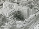
| Date: | 1958 |
|---|---|
| Description: | An aerial view of the contruction of a new wing on the State Office Building. |

| Date: | 04 21 1948 |
|---|---|
| Description: | Aerial photograph of two brush fires on the north side of Lake Mendota. Taken over the west side of Madison looking northwest across Lake Mendota. |

| Date: | 04 21 1948 |
|---|---|
| Description: | Aerial photograph of the west side of Madison and the western edge of Lake Mendota. Taken over the west side of Madison looking northwest toward Middleton. |
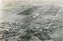
| Date: | 1945 |
|---|---|
| Description: | An aerial view of Truax Field, now also called Dane County Regional Airport. In addition to commercial flights, Truax Field is also home to the Army Nation... |
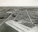
| Date: | 1955 |
|---|---|
| Description: | An aerial view of Truax Field, now also called Dane County Regional Airport. In addition to commercial flights, Truax Field is also home to the Army Nation... |
If you didn't find the material you searched for, our Library Reference Staff can help.
Call our reference desk at 608-264-6535 or email us at: