Filter: Categories of Wisconsin Historical Images
Filter: Subject of Aerial photographs
Filter: County of Dane
Filter: Subject of human settlements
Filter: Categories of Wisconsin Historical Images
Filter: Subject of Aerial photographs
Filter: County of Dane
Filter: Subject of human settlements

| Date: | 1923 |
|---|---|
| Description: | Aerial view of Luther Memorial Church. |
| Date: | 11 1958 |
|---|---|
| Description: | The St. Bernard's Catholic Church during construction. The church was completed in March of 1959. |
| Date: | 1957 |
|---|---|
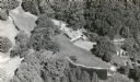
| Description: | An air view of the Maple Bluff Country Club. In the upper lefthand corner is the Rennebohm residence. |
| Date: | 1954 |
|---|---|
| Description: | Aerial view of the Gonstead residence, owned by a well-known chiropractor and designed by Herb Fritz, architect, a student of Frank Lloyd Wright. |

| Date: | |
|---|---|
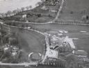
| Description: | Aerial view of Union Corners intersection of East Washington Avenue, Milwaukee Street and North Street looking north. The Rayovac building is in the foregr... |

| Date: | 1947 |
|---|---|
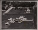
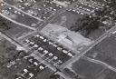
| Description: | Aerial view of one hundred ninety government surplus trailers, parked near Camp Randall, provided temporary housing for World War II veterans and their fam... |
| Date: | 1958 |
|---|---|
| Description: | Aerial view of Orchard Ridge School, at 5602 Russett Road. |

| Date: | 08 1986 |
|---|---|
| Description: | Aerial View of Wisconsin State Capitol. |

| Date: | |
|---|---|
| Description: | Aerial view of Wisconsin State Capitol. |

| Date: | 05 05 1947 |
|---|---|
| Description: | Aerial view of the intersection of Pinckney, Main, and King Streets on the Madison Capitol Square. Kresge's, 27 East Main Street, can be seen at the upper ... |

| Date: | 05 05 1947 |
|---|---|
| Description: | Aerial view of Main, King, and Pinckney Streets intersection on Madison's Capitol Square. View is looking south down Pinckney Street. Kresge's, 27 East Mai... |

| Date: | 05 08 1947 |
|---|---|
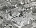
| Description: | Aerial view of the Forsberg Paper Box Company, 2107 Fordem Avenue. View looks to the northeast toward Oscar Mayer. |

| Date: | 05 08 1947 |
|---|---|
| Description: | Aerial photograph of the Capitol Square area of Madison, looking to the southwest. |
| Date: | 10 10 1947 |
|---|---|
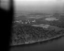
| Description: | Aerial view of the Wisconsin Memorial Hospital run by the Veterans Administration on the north shore of Lake Mendota on the grounds of the Mendota State Ho... |

| Date: | 02 06 1948 |
|---|---|
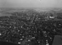
| Description: | Aerial photograph of Madison's west side looking northeast along Speedway Road. Visible are Forest Hill and Resurrection Cemeteries, West High School, Hoyt... |

| Date: | 02 06 1948 |
|---|---|
| Description: | Aerial view of west side, looking south along Glenway Street. Visible are the reservoir, Lake Wingra, Forest Hill and Resurrection Cemetery, Hoyt Park. Maj... |
If you didn't find the material you searched for, our Library Reference Staff can help.
Call our reference desk at 608-264-6535 or email us at: