Filter: Categories of Wisconsin Historical Images
Filter: Subject of Aerial photographs
Filter: County of Dane
Filter: Subject of architecture
Filter: Categories of Wisconsin Historical Images
Filter: Subject of Aerial photographs
Filter: County of Dane
Filter: Subject of architecture

| Date: | 08 08 1976 |
|---|---|
| Description: | Aerial view of the textured steel roof atop the East Towne office of the First Wisconsin National Bank, 4602 East Towne Boulevard. |

| Date: | |
|---|---|
| Description: | Aerial view of a full Camp Randall Stadium during half-time of a football game. The band is on the field in formation to spell "UW." |

| Date: | 1923 |
|---|---|
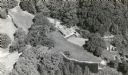
| Description: | Aerial view of Luther Memorial Church. |

| Date: | 08 1986 |
|---|---|
| Description: | Aerial View of Wisconsin State Capitol. |

| Date: | |
|---|---|
| Description: | Aerial view of Wisconsin State Capitol. |

| Date: | 05 08 1947 |
|---|---|
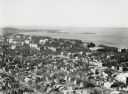
| Description: | Aerial photograph of the Capitol Square area of Madison, looking to the southwest. |

| Date: | 1958 |
|---|---|
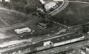
| Description: | An aerial view of the construction of a new wing on a state office building. Automobiles are parked in a log along Lake Monona. |
| Date: | |
|---|---|
| Description: | Aerial view of University Avenue near the Veteran's Administration Hospital. At the bottom is the J.S. Timlin Lumber Company. |

| Date: | |
|---|---|
| Description: | Aerial view of Madison General Hospital and surrounding neighborhood. |

| Date: | |
|---|---|
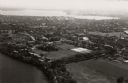
| Description: | University of Wisconsin-Madison Agricultural buildings. The isthmus and Lake Mendota can also be seen. |

| Date: | 1910 |
|---|---|
| Description: | Aerial View of University of Wisconsin-Madison College of Agriculture. Lake Mendota with Picnic Point is in the background. |

| Date: | 1908 |
|---|---|
| Description: | Aerial View of University of Wisconsin-Madison College of Agriculture. Lake Mendota with Picnic Point is in the background. |

| Date: | 1900 |
|---|---|
| Description: | Aerial View of University of Wisconsin-Madison College of Agriculture. Lake Mendota with Picnic Point is in the background. |

| Date: | 1947 |
|---|---|
| Description: | University of Wisconsin-Madison, from Park Street to the men's dormitories. Part of Lake Mendota is in the top right corner. |

| Date: | 1946 |
|---|---|
| Description: | University of Wisconsin-Madison buildings. The General Hospital is in the center, surrounded by homes, trees, and other university buildings. |

| Date: | 1946 |
|---|---|
| Description: | University of Wisconsin-Madison campus on isthmus, including the Agricultural campus and men's dormitories. Part of Lake Mendota is in the top right corner... |
| Date: | 1946 |
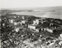
|---|---|
| Description: | View towards southeast of the University of Wisconsin-Madison on isthmus. Lake Mendota is in the lower left corner, and Lake Monona is in the upper portion... |
| Date: | 1924 |
|---|---|
| Description: | University of Wisconsin-Madison lower campus and the surrounding neighborhoods. Lake Mendota and Picnic Point are in the background. |
| Date: | 1924 |
|---|---|
| Description: | University of Wisconsin-Madison aerial view overlooking the lower campus and surrounding neighborhoods. Lake Mendota and Picnic Point are in the background... |
If you didn't find the material you searched for, our Library Reference Staff can help.
Call our reference desk at 608-264-6535 or email us at: