Filter: Categories of Wisconsin Historical Images
Filter: Subject of Aerial photographs
Filter: County of Dane
Filter: Community of Madison
Filter: Categories of Wisconsin Historical Images
Filter: Subject of Aerial photographs
Filter: County of Dane
Filter: Community of Madison

| Date: | 1930 |
|---|---|
| Description: | Aerial view of biplanes at the Pennco Field (Royal Airport), probably for an air show. Lake Monona is in the background. |
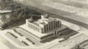
| Date: | 1939 |
|---|---|
| Description: | Aerial view of the Forest Products Laboratory. |
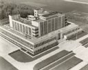
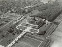
| Date: | 1933 |
|---|---|
| Description: | Aerial view of the Forest Products Laboratory, built in 1932. |
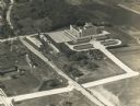
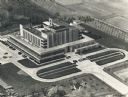
| Date: | 1937 |
|---|---|
| Description: | An aerial view of the Forest Products Laboratory. The view shows a newly completed railroad underpass and street approach. |
| Date: | 1946 |
|---|---|
| Description: | An aerial view of the U.S. Forest Products Laboratory. |

| Date: | 1947 |
|---|---|
| Description: | Aerial view of the Forest Products Laboratory. |
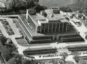
| Date: | 1955 |
|---|---|
| Description: | Aerial view of the Forest Products Laboratory. |

| Date: | 1868 |
|---|---|
| Description: | Elevated view down State Street to the University of Wisconsin from the Wisconsin State Capitol. |
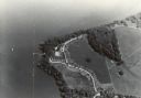
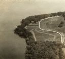
| Date: | |
|---|---|
| Description: | An aerial view of Second Point on Lake Mendota. |
| Date: | |
|---|---|
| Description: | An aerial view of second point on Lake Mendota. |

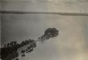
| Date: | |
|---|---|
| Description: | An aerial view of both Picnic Point and Second Point looking toward the isthmus. Members of the Jackson Family had summer homes at Second Point at this tim... |

| Date: | 08 08 1976 |
|---|---|
| Description: | Aerial view of the textured steel roof atop the East Towne office of the First Wisconsin National Bank, 4602 East Towne Boulevard. |

| Date: | |
|---|---|
| Description: | Aerial view of the southeast, with West Broadway and the South Beltline running through the image. Also shows Nob Hill restaurant, the Toki family farm and... |

| Date: | |
|---|---|
| Description: | Aerial view of the Crestwood neighborhood. |

| Date: | |
|---|---|
| Description: | Aerial view of a full Camp Randall Stadium during half-time of a football game. The band is on the field in formation to spell "UW." |

| Date: | 1923 |
|---|---|
| Description: | Aerial view of Luther Memorial Church. |
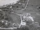
| Date: | 1957 |
|---|---|
| Description: | An air view of the Maple Bluff Country Club. In the upper lefthand corner is the Rennebohm residence. |

| Date: | 10 16 1962 |
|---|---|
| Description: | The intersection of Interstate Highway I-90 and USH 12/18 east of Madison. This view looks toward the southeast |
If you didn't find the material you searched for, our Library Reference Staff can help.
Call our reference desk at 608-264-6535 or email us at: