 Filter: Categories of Wisconsin Historical Images
Filter: Subject of Aerial photographs
Filter: County of Brown
Filter: Subject of rivers
Filter: Categories of Wisconsin Historical Images
Filter: Subject of Aerial photographs
Filter: County of Brown
Filter: Subject of rivers
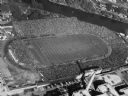
| Date: | 1952 |
|---|---|
| Description: | Aerial view of City Stadium, former home of the Green Bay Packers from 1925 to 1956. Currently it is the home of the Green Bay East High School football te... |
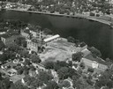
| Date: | 1948 |
|---|---|
| Description: | St. Norbert College campus on the Fox River. |
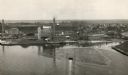
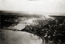
| Date: | 1920 |
|---|---|
| Description: | Aerial view of the conluence of the Fox River and the East River. The Northern Paper Mills are in the foreground and the city is seen to the right. |

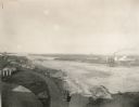
| Date: | 1955 |
|---|---|
| Description: | Aerial view of river and its surrounding landscape. |

| Date: | 1950 |
|---|---|
| Description: | Aerial view of fields near neighborhoods. |

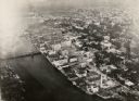
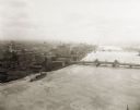
| Date: | 1950 |
|---|---|
| Description: | Aerial view of the confluence of the Fox River and Green Bay. |
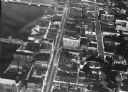
| Date: | 1948 |
|---|---|
| Description: | Aerial view of downtown area, with the Fox River and neighboring suburbs. |
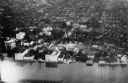
| Date: | 1924 |
|---|---|
| Description: | Aerial view of Green Bay's commercial district, bridges, and water. |
| Date: | 1920 |
|---|---|
| Description: | Aerial view of Green Bay's commercial district on the Fox River. |

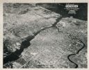
| Date: | 1950 |
|---|---|
| Description: | Aerial view of the Fox River, near Green Bay. Handwritten locations are marked, including: Site of First Court House, Little Rapids, De Pere. |
| Date: | 1920 |
|---|---|
| Description: | Aerial view with fishing piers, coal factories, a bridge, and railroad tracks. |
| Date: | 1920 |
|---|---|
| Description: | Aerial view of Green Bay's commercial waterfront district on the Fox River. |
| Date: | 1925 |
|---|---|
| Description: | Aerial view of Green Bay, including the Jorgensen-Blesch Company building and two bridges. |
| Date: | 1920 |
|---|---|
| Description: | Aerial view of with bridges, river, and shoreline. |

| Date: | 1950 |
|---|---|
| Description: | Aerial view of downtown and river. |

| Date: | |
|---|---|
| Description: | Aerial view of a train crossing the East River in a rural community south of Green Bay. Some buildings are visible to the right and the background of the i... |

| Date: | 1917 |
|---|---|
| Description: | View over the wing of a Lawson Military Tractor 2 (MT2) in flight. Below are houses and what may be a river or lake. Location is unknown, but is probably n... |
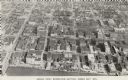
| Date: | 1956 |
|---|---|
| Description: | Caption reads: "Aerial View, Downtown Section, Green Bay, Wis." Text on reverse reads: "This aerial view shows the downtown district of the east side of ... |

| Date: | |
|---|---|
| Description: | Color postcard of downtown Green Bay and bridges spanning the Fox River. The Walnut Street Bridge is in the foreground. A 4-level parking garage is on the ... |
If you didn't find the material you searched for, our Library Reference Staff can help.
Call our reference desk at 608-264-6535 or email us at:
