 Filter: Categories of Wisconsin Historical Images
Filter: Subject of Aerial photographs
Filter: Community of Milwaukee
Filter: Categories of Wisconsin Historical Images
Filter: Subject of Aerial photographs
Filter: Community of Milwaukee
| Date: | |
|---|---|
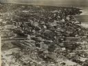
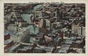
| Description: | Aerial view looking north of downtown, with the Milwaukee River and Lake Michigan. |
| Date: | 1930 |
|---|---|
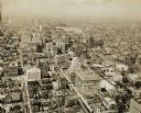
| Description: | Aerial view of downtown area including churches, homes, and large buildings, stretching to the horizon. |
| Date: | 1938 |
|---|---|
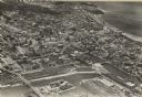
| Description: | Aerial view of rivers, with Lake Michigan in upper right, train yards, and highway in lower left. |

| Date: | 1922 |
|---|---|
| Description: | Aerial view of downtown with City Hall and Milwaukee River. |
| Date: | 1940 |
|---|---|
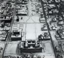
| Description: | Aerial view of courthouse in center foreground with snow on the ground. |

| Date: | 1947 |
|---|---|
| Description: | City Hall near the Milwaukee River. |
| Date: | 1925 |
|---|---|
| Description: | Downtown aerial view with the Milwaukee River and City Hall. Caption reads: "Downtown Aerial View, Milwaukee, Wis." |
| Date: | 1910 |
|---|---|
| Description: | Aerial view of the factory surrounded by fields, roads, and several houses, as well as the railroad tracks that go around the building. Caption reads: "Wes... |

| Date: | 1940 |
|---|---|
| Description: | Aerial view of city, river and harbor. Two smokestacks are on either side of the river mouth. |

| Date: | 1940 |
|---|---|
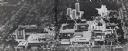
| Description: | Aerial view of the college. Several buildings make up the college, surrounded by paths, roads, fields and trees. Caption reads: "Mount Mary College." |

| Date: | 03 06 1948 |
|---|---|
| Description: | Aerial view of High School, in the upper half of the image, with fields, trees, and roadways surrounding it. In the lower half is a residential neighborho... |
| Date: | 1952 |
|---|---|
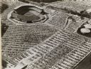
| Description: | Home baseball park for the Milwaukee Braves baseball team. The field is on the upper left, with the rest of the image taken over by the full parking lots. |
| Date: | |
|---|---|
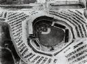
| Description: | Home field of the Milwaukee Braves baseball team. The field is in the center, and is surrounded by a parking lot full of automobiles. |
| Date: | 1972 |
|---|---|
| Description: | Aerial view of Milwaukee campus, with surrounding homes and buildings. |
| Date: | 1966 |
|---|---|
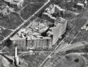
| Description: | St. Mary's Hospital and surrounding area. In the bottom left corner is the water tower. |

| Date: | 1953 |
|---|---|
| Description: | Aerial view looking north from the foot of Milwaukee's main thoroughfare, Wisconsin Avenue. Lincoln Memorial Drive winds its way along the lagoon in Juneau... |
| Date: | |
|---|---|
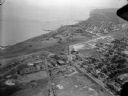
| Description: | Aerial view of lake, in the upper left. A town with dwellings and other buildings are along the shoreline. Part of the airplane is on the right. |

| Date: | |
|---|---|
| Description: | An aerial view of downtown, including a baseball field in the lower left near a train station. |

| Date: | 1930 |
|---|---|
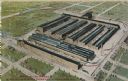
| Description: | Aerial view of International Harvester's Milwaukee Works. |
| Date: | 1982 |
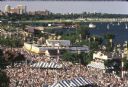
|---|---|
| Description: | Bird's-eye view of a large crowd of music fans gathered at Summerfest, looking northeast toward the current site of Discovery World. Sailboats are on Lake ... |
If you didn't find the material you searched for, our Library Reference Staff can help.
Call our reference desk at 608-264-6535 or email us at: