 Filter: Categories of Wisconsin Historical Images
Filter: Subject of Aerial photographs
Filter: Community of Madison
Filter: Categories of Wisconsin Historical Images
Filter: Subject of Aerial photographs
Filter: Community of Madison

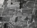
| Date: | 1947 |
|---|---|
| Description: | University of Wisconsin-Madison, from Park Street to the men's dormitories. Part of Lake Mendota is in the top right corner. |

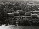
| Date: | 1946 |
|---|---|
| Description: | University of Wisconsin-Madison buildings. The General Hospital is in the center, surrounded by homes, trees, and other university buildings. |

| Date: | 1946 |
|---|---|
| Description: | University of Wisconsin-Madison campus on isthmus, including the Agricultural campus and men's dormitories. Part of Lake Mendota is in the top right corner... |
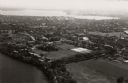
| Date: | 1946 |
|---|---|
| Description: | View towards southeast of the University of Wisconsin-Madison on isthmus. Lake Mendota is in the lower left corner, and Lake Monona is in the upper portion... |
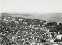
| Date: | 1924 |
|---|---|
| Description: | University of Wisconsin-Madison lower campus and the surrounding neighborhoods. Lake Mendota and Picnic Point are in the background. |
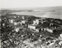
| Date: | 1924 |
|---|---|
| Description: | University of Wisconsin-Madison aerial view overlooking the lower campus and surrounding neighborhoods. Lake Mendota and Picnic Point are in the background... |

| Date: | 1946 |
|---|---|
| Description: | University of Wisconsin-Madison campus, looking south from Lake Mendota. Camp Randall stadium is in the upper right. |

| Date: | 1928 |
|---|---|
| Description: | University of Wisconsin-Madison, looking west. Lake Mendota and Picnic Point are in the upper right of the image. Bascom Hall, the Red Gym, the Wisconsin H... |

| Date: | 1956 |
|---|---|
| Description: | Aerial view over University Avenue of the University of Wisconsin-Madison campus, including University farm in the upper middle. The shoreline of Lake Mend... |

| Date: | 1961 |
|---|---|
| Description: | View over beltline of University of Wisconsin-Madison Arboretum along Lake Wingra. Lake Mendota is on upper left, and Lake Monona is on the right, with the... |
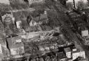
| Date: | 1956 |
|---|---|
| Description: | Aerial view of Birge and Bascom Halls (formerly Main Hall) on the University of Wisconsin-Madison campus. Birge Hall (foreground) with addition under cons... |
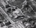
| Date: | 1958 |
|---|---|
| Description: | Aerial view of Chadbourne Hall under construction on the University of Wisconsin-Madison campus. The new building is at the corner of Park Street and Unive... |
| Date: | 1958 |
|---|---|
| Description: | Aerial view of Chadbourne Hall under construction on the University of Wisconsin-Madison campus at the corner of Park Street and University Avenue. Music H... |
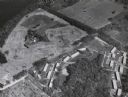
| Date: | 1946 |
|---|---|
| Description: | Aerial view of farm which is part of the University of Wisconsin-Madison. In the foreground is a tree-lined road. The farm has several buildings, including... |
| Date: | 1958 |
|---|---|
| Description: | Aerial View of Eagle Heights Apartments, built especially for married students' housing, under construction on the University of Wisconsin-Madison campus. ... |
| Date: | 1947 |
|---|---|
| Description: | Aerial view of the Elizabeth Waters women's dormitory on the University of Wisconsin-Madison campus. In the upper right corner is Camp Randall. A long pier... |

| Date: | 1948 |
|---|---|
| Description: | Aerial view of the Elizabeth Waters women's dormitory on the University of Wisconsin-Madison campus. The dorm is also referred to as "Liz" or "The Rock". A... |

| Date: | 02 09 1949 |
|---|---|
| Description: | Aerial view of Madison, looking east across the Isthmus including the Wisconsin State Capitol, Lake Mendota, and Lake Monona. |

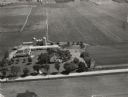
| Date: | 02 09 1949 |
|---|---|
| Description: | One of four aerial views of the Edwin Blaney farm and farm buildings surrounded by snow-covered fields. Four miles south of Madison and a mile west of U.S.... |

| Date: | 06 27 1949 |
|---|---|
| Description: | Aerial photograph looking west across Walnut Street at Forest Products Laboratory and the construction site of the Veterans Administration Hospital. Railr... |
If you didn't find the material you searched for, our Library Reference Staff can help.
Call our reference desk at 608-264-6535 or email us at: