 Filter: Categories of Wisconsin Historical Images
Filter: Subject of Aerial photographs
Filter: Community of Madison
Filter: Subject of farms
Filter: Categories of Wisconsin Historical Images
Filter: Subject of Aerial photographs
Filter: Community of Madison
Filter: Subject of farms
| Date: | 1930 |
|---|---|
| Description: | Aerial view of Turville Point and Turville farm, Lake Monona. |

| Date: | 1956 |
|---|---|
| Description: | Aerial view over University Avenue of the University of Wisconsin-Madison campus, including University farm in the upper middle. The shoreline of Lake Mend... |
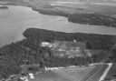
| Date: | 1946 |
|---|---|
| Description: | Aerial view of farm which is part of the University of Wisconsin-Madison. In the foreground is a tree-lined road. The farm has several buildings, including... |
| Date: | 1958 |
|---|---|
| Description: | Aerial View of Eagle Heights Apartments, built especially for married students' housing, under construction on the University of Wisconsin-Madison campus. ... |

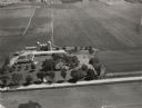
| Date: | 02 09 1949 |
|---|---|
| Description: | One of four aerial views of the Edwin Blaney farm and farm buildings surrounded by snow-covered fields. Four miles south of Madison and a mile west of U.S.... |

| Date: | 07 15 1958 |
|---|---|
| Description: | Aerial view of Eagle Heights Farm, Eagle Heights Woods and part of Lake Mendota. Sites labeled on the image are Eagle Heights, Tent Colony, Apartment Site,... |

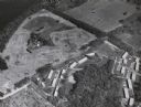
| Date: | 1960 |
|---|---|
| Description: | Aerial view of rural landscape with suburban construction in foreground. Cottage Grove Road is at left with the newly constructed Acewood Boulevard crossin... |
If you didn't find the material you searched for, our Library Reference Staff can help.
Call our reference desk at 608-264-6535 or email us at: