Filter: Categories of Wisconsin Historical Images
Filter: Subject of Aerial photographs
Filter: Community of Madison
Filter: Creator Name of Unknown
Filter: Categories of Wisconsin Historical Images
Filter: Subject of Aerial photographs
Filter: Community of Madison
Filter: Creator Name of Unknown
| Date: | 1945 |
|---|---|
| Description: | Aerial view of Madison over the University Avenue-Randall Stadium area, looking toward the Congregationalist Church and the U.S. Forest Products Laboratory... |

| Date: | 1924 |
|---|---|
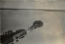
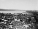
| Description: | Aerial view of Madison's Willow Beach towards the University of Wisconsin-Madison campus, downtown Madison, and Lake Monona. |
| Date: | 1924 |
|---|---|
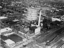
| Description: | Aerial view of a Madison Gas and Electric steam plant. |

| Date: | 1930 |
|---|---|
| Description: | Aerial view above Shorewood Hills near Madison, looking northeast. |
| Date: | 1924 |
|---|---|
| Description: | Aerial view looking southwest over Madison's Vilas Park. |

| Date: | 07 06 1937 |
|---|---|
| Description: | Aerial view of the west central part of isthmus and the University of Wisconsin campus. |

| Date: | |
|---|---|
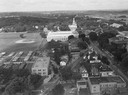
| Description: | Aerial view over the Wisconsin State Capitol looking south south-east. |
| Date: | 1937 |
|---|---|
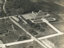
| Description: | An aerial view of the Forest Products Laboratory. The view shows a newly completed railroad underpass and street approach. |

| Date: | 1947 |
|---|---|
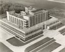
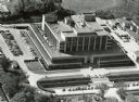
| Description: | Aerial view of the Forest Products Laboratory. |
| Date: | 1955 |
|---|---|
| Description: | Aerial view of the Forest Products Laboratory. |
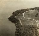
| Date: | |
|---|---|
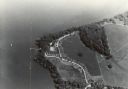
| Description: | An aerial view of Second Point on Lake Mendota. |
| Date: | |
|---|---|
| Description: | An aerial view of second point on Lake Mendota. |

| Date: | 10 16 1962 |
|---|---|
| Description: | The intersection of Interstate Highway I-90 and USH 12/18 east of Madison. This view looks toward the southeast |

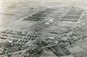
| Date: | 1947 |
|---|---|
| Description: | Aerial view of one hundred ninety government surplus trailers, parked near Camp Randall, provided temporary housing for World War II veterans and their fam... |
| Date: | 1945 |
|---|---|
| Description: | An aerial view of Truax Field, now also called Dane County Regional Airport. In addition to commercial flights, Truax Field is also home to the Army Nation... |
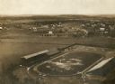
| Date: | 1909 |
|---|---|
| Description: | Aerial view looking north over Camp Randall stadium towards University Heights. In the right-center area of the photograph, the Wayland J. Chase residence,... |

| Date: | 1910 |
|---|---|
| Description: | Aerial view looking toward Lake Wingra. In the foreground is the Yawkey-Crowley Lumber Yard. The company built it's warehouse at 1542 Monroe Street between... |

| Date: | 1875 |
|---|---|
| Description: | A full circle panorama as it would be seen from the top of the Wisconsin State Capitol. This painting was based on photographs perhaps taken by Edward Niel... |
If you didn't find the material you searched for, our Library Reference Staff can help.
Call our reference desk at 608-264-6535 or email us at: