 Filter: Categories of Wisconsin Historical Images
Filter: Subject of Aerial photographs
Filter: Creator Name of Vinje, Arthur M., 1888-1972
Filter: Categories of Wisconsin Historical Images
Filter: Subject of Aerial photographs
Filter: Creator Name of Vinje, Arthur M., 1888-1972
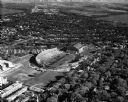
| Date: | 05 11 1951 |
|---|---|
| Description: | Aerial view of Camp Randall Stadium and Fieldhouse looking south. The photograph was taken during a ROTC annual inspection. |

| Date: | 1945 |
|---|---|
| Description: | Aerial view of downtown Madison in the before construction of the Wisconsin Telephone Company in 1947 at the corner of South Fairchild Street and East Main... |

| Date: | 05 11 1951 |
|---|---|
| Description: | Aerial view of downtown Madison looking from State Street to King Street. |

| Date: | 05 11 1951 |
|---|---|
| Description: | Aerial view of downtown Madison looking from West Washington Avenue to East Washington Avenue. |

| Date: | 04 17 1952 |
|---|---|
| Description: | Aerial view of Madison taken from near the site of the WIBA radio tower, looking east toward the isthmus. Other images in this set look to the northwest, s... |

| Date: | 04 17 1952 |
|---|---|
| Description: | Aerial view of Madison looking toward the capitol building from over East Washington Avenue and Commercial Avenue. Other images in this set look toward the... |

| Date: | 06 17 1952 |
|---|---|
| Description: | Aerial photos probably of Madison, looking north east from intersection of Nakoma Road (Hwy. 18-151) and West Beltline Highway (Hwy. 12-18) toward Isthmus,... |

| Date: | 10 17 1952 |
|---|---|
| Description: | Aerial view of Madison General Hospital and surrounding neighborhood. |

| Date: | 10 17 1952 |
|---|---|
| Description: | Aerial view of Madison General Hospital and the surrounding Greenbush and Vilas neighborhoods with Camp Randall and Lake Mendota in the background. |

| Date: | 10 18 1952 |
|---|---|
| Description: | Aerial view of Madison General Hospital and the surrounding Greenbush and Vilas neighborhoods. Also visible is Monona Bay with Camp Randall and Picnic Poi... |

| Date: | 10 18 1952 |
|---|---|
| Description: | Aerial view of Madison General Hospital, the surrounding Greenbush and Vilas neighborhoods, and Camp Randall in the background. |

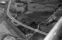
| Date: | 02 02 1953 |
|---|---|
| Description: | Aerial photo of the Crawford Heights area of Madison, showing the West Beltline Highway, Nakoma road, Verona Road, Hammersley Road and the Vinkingtown Mote... |

| Date: | 12 23 1953 |
|---|---|
| Description: | Aerial view of Crawford Heights looking northwest across Nakoma Road. The photograph shows Nakoma Road, the West Beltline, Cherokee School, and Midvale Bou... |

| Date: | 12 23 1953 |
|---|---|
| Description: | Aerial view of Crawford Heights looking north along Midvale Boulevard. The photograph shows Nakoma Road, the West Beltline, Cherokee School, and Midvale Bo... |

| Date: | 12 23 1953 |
|---|---|
| Description: | Aerial view of Crawford Heights looking northeast along Nakoma Road, across the West Beltline. The photograph shows Midvale Boulevard and Lake Mendota appe... |

| Date: | 12 22 1953 |
|---|---|
| Description: | Aerial photograph of Crawford Heights looking west along the West Beltline. The photograph shows Nakoma Road, Midvale Boulevard, Cherokee School, and the A... |

| Date: | 12 23 1953 |
|---|---|
| Description: | Aerial view of Crawford Heights looking west along the West Beltline. The photograph shows Nakoma Road, Midvale Boulevard, Cherokee School, and the Arboret... |

| Date: | 12 23 1953 |
|---|---|
| Description: | Aerial view of Crawford Heights looking north by northwest along the West Beltline with Cherokee School and the Arboretum at lower right and Lake Mendota a... |
| Date: | 1958 |
|---|---|
| Description: | Aerial view of Kapec Orchards on Verona Road between McKee and Nesbitt Roads. |

| Date: | 07 14 1958 |
|---|---|
| Description: | This is a Tellurometer, a microwave surveying instrument. The operator is Don Reed, field man for Alster and Associates, Washington, D.C., which completed ... |
If you didn't find the material you searched for, our Library Reference Staff can help.
Call our reference desk at 608-264-6535 or email us at: