 Filter: Categories of Wisconsin Historical Images
Filter: Subject of Aerial photographs
Filter: Creator Name of Vinje, Arthur M., 1888-1972
Filter: Categories of Wisconsin Historical Images
Filter: Subject of Aerial photographs
Filter: Creator Name of Vinje, Arthur M., 1888-1972
| Date: | 04 30 1949 |
|---|---|
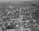
| Description: | Aerial photograph of Dodgeville. The Iowa County Courthouse is visible upper center left. |

| Date: | 04 30 1949 |
|---|---|
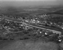
| Description: | Aerial photograph of Blanchardville. |
| Date: | 04 30 1949 |
|---|---|
| Description: | Aerial photograph of Barneveld, Wisconsin. |

| Date: | 04 30 1949 |
|---|---|
| Description: | Aerial photograph of contour farming in Wisconsin. |

| Date: | 06 27 1949 |
|---|---|
| Description: | Aerial photograph looking west across Walnut Street at Forest Products Laboratory and the construction site of the Veterans Administration Hospital. Railr... |

| Date: | 06 27 1949 |
|---|---|
| Description: | Aerial photograph looking west along University Avenue at Forest Products Laboratory and the construction site for the Veterans Administration Hospital. |

| Date: | 06 27 1949 |
|---|---|
| Description: | Aerial photograph looking north across University Avenue at the construction site for the Veterans Administration Hospital. |

| Date: | 06 27 1949 |
|---|---|
| Description: | Aerial photograph looking south across the construction site for the Veterans Administration hospital and University Avenue. |

| Date: | 06 27 1949 |
|---|---|
| Description: | Aerial photograph looking north across University Avenue at Forest Products Laboratory and the construction site for the Veterans Administration hospital. |

| Date: | 05 27 1949 |
|---|---|
| Description: | Aerial photograph looking north across University Avenue at the construction site for the Veterans Administration hospital. |

| Date: | 07 12 1949 |
|---|---|
| Description: | Aerial view of the residence of Mrs. George M. Fisk, 325 Lakewood Blvd., and other homes along the shore of Lake Mendota in Maple Bluff. Ida Johnson Fisk, ... |

| Date: | 10 07 1949 |
|---|---|
| Description: | Aerial photograph of the Glenway Park area on Madison west side, looking south across Glenway Street and the Illinois Central Railroad. Glen Drive is on th... |

| Date: | 10 07 1949 |
|---|---|
| Description: | Aerial photograph of the Glenway Park area on Madison west side, looking north from Monroe Street across the Illinois Central Railroad. Glen Drive can be s... |

| Date: | 10 07 1949 |
|---|---|
| Description: | Aerial photograph of the Glenway Park area on Madison west side, looking west across Monroe Street and Dudgeon School (3200 Monroe Street). Glenway golf co... |

| Date: | 10 07 1949 |
|---|---|
| Description: | Aerial photograph of the Westminster Presbyterial Church site on Madison west side, looking northeast along Nakoma Road at Yuma Drive and Seminole Highway. |

| Date: | 10 07 1949 |
|---|---|
| Description: | Aerial photograph of the Westminster Presbyterian Church site on Madison's west side, looking south across Nakoma Road at Yuma Drive and along Seminole Hig... |

| Date: | 10 07 1949 |
|---|---|
| Description: | Aerial photograph of the Westminster Presbyterian Church site on Madison west side, looking south across Nakoma Road at Yuma Drive. |

| Date: | 04 27 1951 |
|---|---|
| Description: | A composite map of the Madison area taken from aerial photos by Abrams Aerial Survey Corporation for the Madison Planning Commission. |
| Date: | 05 11 1951 |
|---|---|
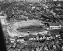
| Description: | Aerial view of Camp Randall Stadium and Fieldhouse looking east taken. The photograph was taken during a ROTC annual inspection. |
| Date: | 05 11 1951 |
|---|---|
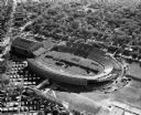
| Description: | Aerial view of Camp Randall Stadium and Fieldhouse looking west. The photograph was taken during a ROTC annual inspection. |
If you didn't find the material you searched for, our Library Reference Staff can help.
Call our reference desk at 608-264-6535 or email us at: