 Filter: Categories of Wisconsin Historical Images
Filter: Subject of Aerial photographs
Filter: Creator Name of Unknown
Filter: Categories of Wisconsin Historical Images
Filter: Subject of Aerial photographs
Filter: Creator Name of Unknown

| Date: | 1965 |
|---|---|
| Description: | Elevated view of roads, railroad tracks, building, farm fields, and a body of water. |

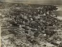
| Date: | 1915 |
|---|---|
| Description: | Advertisement reads: "Castle-Pierce Printing Company" and "Feb. 1915". Text on right reads: "The Heart of Oshkosh. This birds-eye view represents about one... |
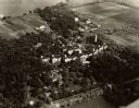
| Date: | 1935 |
|---|---|
| Description: | Aerial view of the Northern Wisconsin Hospital for the Insane. |

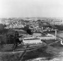
| Date: | 1947 |
|---|---|
| Description: | Aerial view of Monroe. A large building with a clock tower, commercial buildings, parking lots and automobiles can be seen. |
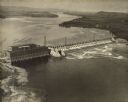
| Date: | 1924 |
|---|---|
| Description: | Aerial view of the Prairie du Sac hydroelectric plant and the surrounding landscape of the Wisconsin River. |
| Date: | 01 1973 |
|---|---|
| Description: | Aerial view of the Falk Corporation. Falk caption reads, "Black and white negatives, furnished to advertising department by J. Blank. See similar color pic... |

| Date: | 10 30 1990 |
|---|---|
| Description: | Original Falk caption reads, "Aerial view [of] main plant (October 1990)." |
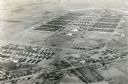
| Date: | 1945 |
|---|---|
| Description: | An aerial view of Truax Field, now also called Dane County Regional Airport. In addition to commercial flights, Truax Field is also home to the Army Nation... |
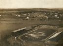
| Date: | 1909 |
|---|---|
| Description: | Aerial view looking north over Camp Randall stadium towards University Heights. In the right-center area of the photograph, the Wayland J. Chase residence,... |

| Date: | 1910 |
|---|---|
| Description: | Aerial view looking toward Lake Wingra. In the foreground is the Yawkey-Crowley Lumber Yard. The company built it's warehouse at 1542 Monroe Street between... |

| Date: | 1875 |
|---|---|
| Description: | A full circle panorama as it would be seen from the top of the Wisconsin State Capitol. This painting was based on photographs perhaps taken by Edward Niel... |

| Date: | 1950 |
|---|---|
| Description: | Harbor area of Jones Island and garbage disposal plant, Stratton Grain Co., and more. |

| Date: | 1950 |
|---|---|
| Description: | Divided highway is South Chase Avenue between West Lincoln Avenue (2300) and East Oklahoma Avenue (3100). |
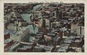
| Date: | |
|---|---|
| Description: | Aerial view looking north of downtown, with the Milwaukee River and Lake Michigan. |
| Date: | 1925 |
|---|---|
| Description: | Downtown aerial view with the Milwaukee River and City Hall. Caption reads: "Downtown Aerial View, Milwaukee, Wis." |
| Date: | 1910 |
|---|---|
| Description: | Aerial view of the factory surrounded by fields, roads, and several houses, as well as the railroad tracks that go around the building. Caption reads: "Wes... |

| Date: | 1940 |
|---|---|
| Description: | Aerial view of city, river and harbor. Two smokestacks are on either side of the river mouth. |

| Date: | 1940 |
|---|---|
| Description: | Aerial view of the college. Several buildings make up the college, surrounded by paths, roads, fields and trees. Caption reads: "Mount Mary College." |
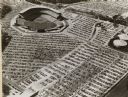
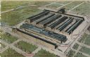
| Date: | 1952 |
|---|---|
| Description: | Home baseball park for the Milwaukee Braves baseball team. The field is on the upper left, with the rest of the image taken over by the full parking lots. |
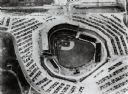
| Date: | |
|---|---|
| Description: | Home field of the Milwaukee Braves baseball team. The field is in the center, and is surrounded by a parking lot full of automobiles. |
If you didn't find the material you searched for, our Library Reference Staff can help.
Call our reference desk at 608-264-6535 or email us at: