 Filter: Categories of Wisconsin Historical Images
Filter: Subject of Aerial photographs
Filter: Creator Name of Newhouse, John
Filter: Categories of Wisconsin Historical Images
Filter: Subject of Aerial photographs
Filter: Creator Name of Newhouse, John

| Date: | 03 1962 |
|---|---|
| Description: | Aerial view with beginning of construction on Sellery Hall on the block bounded by Park, West Johnson, Murray, and West Dayton Streets. Park Street runs fr... |

| Date: | 1965 |
|---|---|
| Description: | Air view of the west end of University of Wisconsin-Madison campus with U.W. Hospital and U.W. athletic fields at top. Campus Drive and University Avenue r... |

| Date: | 1968 |
|---|---|
| Description: | Air view of the University of Wisconsin-Madison campus looking north to Lake Mendota. Picnic Point, currently part of the Lakeshore Nature Preserve, and Ca... |

| Date: | 1962 |
|---|---|
| Description: | Aerial view of the Hilldale Shopping Center and environs. Anchor store is Gimbels. N. Midvale Boulevard runs left to right. The State Department of Transpo... |

| Date: | 1967 |
|---|---|
| Description: | Air view looking north toward Lake Mendota. The intersection of West Washington Ave. and S. Park Street is at bottom center. The Triangle Redevelopment Pro... |

| Date: | 1960 |
|---|---|
| Description: | Air view focused on the Greenbush neighborhood of Madison prior to its demolition for the Triangle Redevelopment Project. Monona Bay and Brittingham Park a... |

| Date: | |
|---|---|
| Description: | Aerial view of the Greenbush neighborhood in winter partially demolished for the Triangle Redevelopment Project. Monona Bay and Brittingham park are at rig... |
| Date: | 1963 |
|---|---|
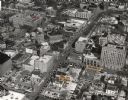
| Description: | Aerial view of downtown Madison focused on Mifflin and Fairchild Streets with the site of the new Madison Public Library marked. Mifflin Street runs diagon... |
| Date: | 1963 |
|---|---|
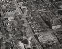
| Description: | Aerial view showing University Avenue running diagonally from top to bottom. Chadbourne Hall at the intersection of University and N. Park Street is at bot... |

| Date: | 1964 |
|---|---|
| Description: | Aerial view of the Sampson Plaza apartment complex on West Washington Avenue, with Proudfit Street running along the bottom. Neighborhood House can be seen... |

| Date: | |
|---|---|
| Description: | Caption reads: "Madison, Wis. Air view of football practice field and stadium of the University of Wisconsin." |

| Date: | 1954 |
|---|---|
| Description: | Aerial view of the construction of Herbert Schenk Elementary School, as well as the surrounding neighborhood. |
If you didn't find the material you searched for, our Library Reference Staff can help.
Call our reference desk at 608-264-6535 or email us at: