Filter: Categories of Wisconsin Historical Images
Filter: Subject of Aerial photographs
Filter: Type of Photograph
Filter: Community of La Crosse
Filter: Categories of Wisconsin Historical Images
Filter: Subject of Aerial photographs
Filter: Type of Photograph
Filter: Community of La Crosse

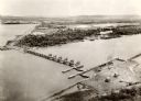
| Date: | 1955 |
|---|---|
| Description: | Aerial view of river and town from a military airplane. |

| Date: | 1955 |
|---|---|
| Description: | Aerial view of La Crosse, with Onalaska in the background. The highway is U.S. Highway 53 and the State Highway 35. |

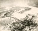
| Date: | 1953 |
|---|---|
| Description: | Aerial view of La Crosse and the Mississippi River. In the foreground is the new bridge as of 1953. |
| Date: | 1935 |
|---|---|
| Description: | An aerial view of La Crosse and the Mississippi River with the bridge drawn in to show what the finished product would look like. |

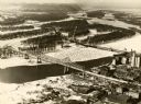
| Date: | 1940 |
|---|---|
| Description: | Aerial view of the bridge spanning the Mississippi River in La Crosse. |
| Date: | 1940 |
|---|---|
| Description: | The bridge spanning the Mississippi River in La Crosse. |
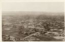
| Date: | |
|---|---|
| Description: | Aerial view of La Crosse, with the Mississippi River in the distance. |

| Date: | 1950 |
|---|---|
| Description: | Aerial view of a farm and surrounding fields farmed with the contour method. Shocks of grain dot several of the fields. |
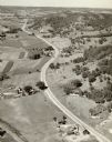
| Date: | |
|---|---|
| Description: | Aerial view of a road, with several farms, fields and hills along it. Caption reads: "U.S. 16 near La Crosse, Wis." |
If you didn't find the material you searched for, our Library Reference Staff can help.
Call our reference desk at 608-264-6535 or email us at: