Filter: Categories of Wisconsin Historical Images
Filter: Subject of Administrative agencies
Filter: Year of 1800-1899
Filter: Subject of cities and towns
Filter: Categories of Wisconsin Historical Images
Filter: Subject of Administrative agencies
Filter: Year of 1800-1899
Filter: Subject of cities and towns

| Date: | 1855 |
|---|---|
| Description: | Detail from a lithograph vignette on a Map of the City of Madison of the third Wisconsin State Capitol, the first Capitol in Madison. |
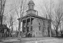
| Date: | 1880 |
|---|---|
| Description: | Exterior view of the St. Croix County Court House with six people standing in front of it. |
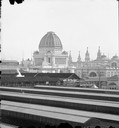
| Date: | 1893 |
|---|---|
| Description: | Elevated view of terminal station at Jackson Park; Administration Building in background. |
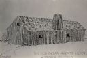
| Date: | 1897 |
|---|---|
| Description: | The Indian Agency House when the land was farmed by E.S. Baker of Portage, Wisconsin. |

| Date: | 1883 |
|---|---|
| Description: | A hand-colored map of Wisconsin showing the nine congressional districts, it also shows the counties, cities, railroads, rivers, and lakes in the state. |

| Date: | 1845 |
|---|---|
| Description: | Wisconsin was considered part of Michigan Territory until 1836, a year before Michigan entered statehood. Drawn three years before Wisconsin entered stateh... |

| Date: | 1889 |
|---|---|
| Description: | Shows city limits, railroads, mills, schools, cemeteries, dams, parks, lumber yards, log canals, log reservoir, Chippewa River, Eau Claire River, and Half ... |

| Date: | 1853 |
|---|---|
| Description: | A map of Wellfleet Harbor on Cape Cod Bay. |
If you didn't find the material you searched for, our Library Reference Staff can help.
Call our reference desk at 608-264-6535 or email us at: