 Filter: Categories of Wisconsin Historical Images
Filter: FULL_DATE of 1990
Filter: Subject of service industries
Filter: Subject of human settlements
Filter: Categories of Wisconsin Historical Images
Filter: FULL_DATE of 1990
Filter: Subject of service industries
Filter: Subject of human settlements
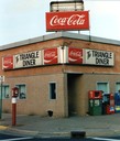
| Date: | 1990 |
|---|---|
| Description: | Exterior view of the The Triangle Diner. A large Coca-Cola sign is on top of the diner. |

| Date: | 1990 |
|---|---|
| Description: | "Tanknology" employee inspecting gasoline at "Cenex" gas station. |

| Date: | 1990 |
|---|---|
| Description: | A tourist map of Lafayette County, Wisconsin, that shows the locations of motels, camping, municipal parks, cheese factory tours, waysides, and golf course... |

| Date: | 1990 |
|---|---|
| Description: | This tourism brochure of Ashland County, Wisconsin, from the Ashland Area Chamber of Commerce includes a map of the county showing tourist destinations and... |

| Date: | 1990 |
|---|---|
| Description: | This map shows the Minnesota Point, Wisconsin Point, Hog Island, Baker's Island, Connors Point, Blatnik Bridge, Superior Bay, Allouez Bay, the Nemadji Rive... |

| Date: | 1990 |
|---|---|
| Description: | This map shows various types of trails, boat landings, canoe areas, public beaches, picnic areas, campgrounds, golf courses, public tennis courts, and othe... |
If you didn't find the material you searched for, our Library Reference Staff can help.
Call our reference desk at 608-264-6535 or email us at: