 Filter: Categories of Wisconsin Historical Images
Filter: FULL_DATE of 1990
Filter: Subject of land
Filter: Categories of Wisconsin Historical Images
Filter: FULL_DATE of 1990
Filter: Subject of land

| Date: | 1990 |
|---|---|
| Description: | A tourist map of Lafayette County, Wisconsin, that shows the locations of motels, camping, municipal parks, cheese factory tours, waysides, and golf course... |

| Date: | 1990 |
|---|---|
| Description: | This late 20th century tourist map of Sauk County, Wisconsin, shows the highways and roads, cities and towns, parks, airports, canoe landings, hospitals, s... |

| Date: | 1990 |
|---|---|
| Description: | This tourism brochure of Ashland County, Wisconsin, from the Ashland Area Chamber of Commerce includes a map of the county showing tourist destinations and... |
| Date: | 1990 |
|---|---|
| Description: | Color photo of a person driving an International Harvester school bus. This photograph was likely taken for promotional or advertisement material for the b... |
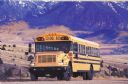
| Date: | 1990 |
|---|---|
| Description: | Color photo of a person driving an International school bus in the southwest United States. In the background is a snow-capped mountain range. This photogr... |
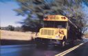
| Date: | 1990 |
|---|---|
| Description: | Color photo of an International school bus, shown in a blur of motion on a road. The "International" emblem is on the grille of the bus, and there is a mal... |
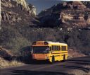
| Date: | 1990 |
|---|---|
| Description: | Color photograph of an International school bus parked on a road in a desert setting. The bus driver is barely visible through the front windshield. This i... |
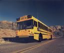
| Date: | 1990 |
|---|---|
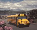
| Description: | Color photo of an International school bus with a man in the driver's seat. The bus is in the middle of a street in a hilly residential area, with landscap... |
| Date: | 1990 |
|---|---|
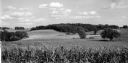
| Description: | The location of the former Dunham school as seen from the Quinney farm. In the foreground is a field of corn, with rolling hills and trees in the backgroun... |
| Date: | 1990 |
|---|---|
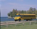
| Description: | Color photo of an International school bus driven along a coastal road. In the foreground is a split-rail fence and lawn. The photograph was probably taken... |
| Date: | 1990 |
|---|---|
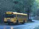
| Description: | Color photo of an International school bus driving on a road through a heavily wooded area on a rainy day. The driver is obscured by the rear view mirrors ... |
| Date: | 1990 |
|---|---|
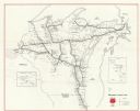
| Description: | This map shows main railroad track, lines out of service, abandoned lines, and trackage rights. The back of the map shows Wisconsin Central Ltd. lines and ... |

| Date: | 1990 |
|---|---|
| Description: | This map shows the Minnesota Point, Wisconsin Point, Hog Island, Baker's Island, Connors Point, Blatnik Bridge, Superior Bay, Allouez Bay, the Nemadji Rive... |
| Date: | 1990 |
|---|---|
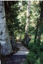
| Description: | A boardwalk that goes thorough the woods from the main lodge at Forest Lodge to the boathouse. The boardwalk is lined with mature birch trees and ferns, a... |
If you didn't find the material you searched for, our Library Reference Staff can help.
Call our reference desk at 608-264-6535 or email us at: