 Filter: Categories of Wisconsin Historical Images
Filter: FULL_DATE of 1979
Filter: Subject of rivers
Filter: Categories of Wisconsin Historical Images
Filter: FULL_DATE of 1979
Filter: Subject of rivers
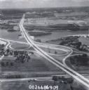
| Date: | 1979 |
|---|---|
| Description: | Interstate I-90 and State Highway 35 at La Crosse. |

| Date: | 1979 |
|---|---|
| Description: | A map of Southern Wisconsin and northern Illinois showing the areas inhabited by the Ho-Chuck, formerly known as the Winnebago. Some of the location names ... |

| Date: | 1979 |
|---|---|
| Description: | Elevated view of boathouses floating on the water at piers along the shore of the Black River. Some of the boathouses have been owned by many generations o... |

| Date: | 1979 |
|---|---|
| Description: | Geese and ducks on the shoreline and in the water, seen through trees. A paved road is in the foreground, and the far shoreline is wooded. |

| Date: | 1979 |
|---|---|
| Description: | Two canoeists navigate the rapids, called Gilmore's Mistake, on the Wolf River. Rocks and foliage can be seen on the shore. |
If you didn't find the material you searched for, our Library Reference Staff can help.
Call our reference desk at 608-264-6535 or email us at:
