 Filter: Categories of Wisconsin Historical Images
Filter: FULL_DATE of 1979
Filter: Subject of land
Filter: Subject of transportation
Filter: Categories of Wisconsin Historical Images
Filter: FULL_DATE of 1979
Filter: Subject of land
Filter: Subject of transportation

| Date: | 1979 |
|---|---|
| Description: | Aerial view of Interstate I-90/94 at Camp Douglas, looking northwest. |

| Date: | 1979 |
|---|---|
| Description: | Aerial view of the International Harvester Springfield plant. |

| Date: | 1979 |
|---|---|
| Description: | Man standing on 1420 axial-flow combine near a pond or lake, near another man sitting in a boat holding a fishing pole. |
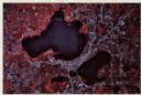
| Date: | 1979 |
|---|---|
| Description: | Text on reverse reads: "Madison, Wisconsin photographed on infrared film at an altitude of 22 miles from a NASA research aircraft. Red = vegetation Blue ... |
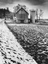
| Date: | 1979 |
|---|---|
| Description: | A barn and silo, on a snow covered farm along Highway 78, between Mt. Horeb and Black Earth. The farmhouse is behind the barn. A barbed wire fence lines th... |
If you didn't find the material you searched for, our Library Reference Staff can help.
Call our reference desk at 608-264-6535 or email us at:
