 Filter: Categories of Wisconsin Historical Images
Filter: FULL_DATE of 1979
Filter: Subject of lakes
Filter: Categories of Wisconsin Historical Images
Filter: FULL_DATE of 1979
Filter: Subject of lakes

| Date: | 1979 |
|---|---|
| Description: | A map of Southern Wisconsin and northern Illinois showing the areas inhabited by the Ho-Chuck, formerly known as the Winnebago. Some of the location names ... |

| Date: | 1979 |
|---|---|
| Description: | Map of the University of Wisconsin-Madison re-imagined as "Dizzyland", the campus taken over the by the student government party Pail and Shovel. The map s... |

| Date: | 1979 |
|---|---|
| Description: | View of the sunken Statue of Liberty created by legendary University of Wisconsin student Leon Varjian. |
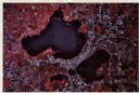
| Date: | 1979 |
|---|---|
| Description: | Text on reverse reads: "Madison, Wisconsin photographed on infrared film at an altitude of 22 miles from a NASA research aircraft. Red = vegetation Blue ... |
If you didn't find the material you searched for, our Library Reference Staff can help.
Call our reference desk at 608-264-6535 or email us at:
