 Filter: Categories of Wisconsin Historical Images
Filter: FULL_DATE of 1976
Filter: Subject of water
Filter: Categories of Wisconsin Historical Images
Filter: FULL_DATE of 1976
Filter: Subject of water
| Date: | 1976 |
|---|---|
| Description: | Color advertising photograph of a fisherman unloading gear from the rear of an International Scout II XL pickup near a mountain lake. |

| Date: | 1976 |
|---|---|
| Description: | Color photograph of International Transtar Eagle Semi Tractors in the standard cab and cabover models parked beside a body of water. |
| Date: | 1976 |
|---|---|
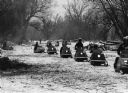
| Description: | "Snowmobiles make their way along the Rock River." |
| Date: | 1976 |
|---|---|
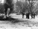
| Description: | "Theresa Lions Club members have a cleanup day on the Rock River." |
| Date: | 1976 |
|---|---|
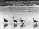
| Description: | "Canadian geese 'goose step' on ice on the Theresa Marsh." |

| Date: | 1976 |
|---|---|
| Description: | An 1876 reprinted map of the Township of Franklin, Milwaukee County, Wisconsin, that shows the land ownership and sectioning of the town, as well as the ro... |

| Date: | 1976 |
|---|---|
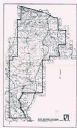
| Description: | A street map of Milwaukee County, Wisconsin that identifies the location of schools, hospitals, parks, beaches, streets, freeways, both planned or under co... |

| Date: | 1976 |
|---|---|
| Description: | Panel title. Shows railroads, roads, highways, boundaries, dams, public hunting and fishing grounds, cemeteries, forest ranger stations, plant life, and s... |

| Date: | 1976 |
|---|---|
| Description: | Jane Leeney, in red, white, and blue pants, shirt, and a hat is sitting on a cliff. She is holding a large flag, and a sign beside her reads, "1776-1976 Ha... |

| Date: | 1976 |
|---|---|
| Description: | Indexed map of campus buildings, streets, and residence halls. Also included on the map is information about buses. The back of the map features campus bus... |

| Date: | 1976 |
|---|---|
| Description: | On Memorial Day American Legion Member Oliver Krueger drops a wreath into the Rock River. |

| Date: | 1976 |
|---|---|
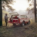
| Description: | A man and a woman are standing in the grass near a small body of water and a white colored Scout II XLC. Near the parked vehicle is a red tent and a chair ... |

| Date: | 1976 |
|---|---|
| Description: | This map includes an index of streets, government and historic buildings, hospitals, schools, places of recreation, churches, cemeteries, and other miscell... |

| Date: | 1976 |
|---|---|
| Description: | This hand-colored map shows land divided by forest type and tree species. Also shown are counties, Lake Michigan, Lake Superior, Lake Winnebago, and the Mi... |
| Date: | 1976 |
|---|---|
| Description: | This map shows Wisconsin River Watershed, adjacent watersheds, and railroads in parts of Vilas, Oneida, Forest, Lincoln, Langlade, Marathon, Wood, Portage,... |
| Date: | 1976 |
|---|---|
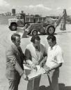
| Description: | Slightly elevated view of three men standing outdoors and looking at a map. Behind them is a dump truck and a loader/backhoe. In the background is a city s... |
| Date: | 1976 |
|---|---|
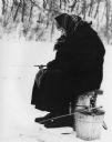
| Description: | A woman wearing a hat and a plaid scarf over her head is ice fishing in Governor Dodge State Park. She is sitting on a bucket with her feet on a board. |
| Date: | 1976 |
|---|---|
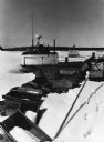
| Description: | Fishing boats wintering on Lake Superior, which is frozen and covered with snow. Wooden fishing boxes are strewn in the foreground, and a wooded shoreline ... |
| Date: | 1976 |
|---|---|
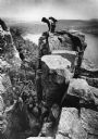
| Description: | View towards a rock climber on top of an outcropping at Devil's Lake State Park who is watching another climber descending. Devil's Lake and bluffs are in ... |
If you didn't find the material you searched for, our Library Reference Staff can help.
Call our reference desk at 608-264-6535 or email us at: