 Filter: Categories of Wisconsin Historical Images
Filter: FULL_DATE of 1976
Filter: Subject of tourism
Filter: Categories of Wisconsin Historical Images
Filter: FULL_DATE of 1976
Filter: Subject of tourism
| Date: | 1976 |
|---|---|
| Description: | Intended for tourists, the front of this guide includes twelve county bicycle maps and text. The reverse includes four maps of state trails and nine maps o... |
| Date: | 1976 |
|---|---|
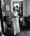
| Description: | "Evangeline Koll guides visitors at the Solomon Juneau House." |
| Date: | 1976 |
|---|---|
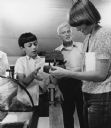
| Description: | "Darryl Koll demonstrates Solomon Juneau's mouse trap to Ralph Widmer and a visitor from Switzerland." |

| Date: | 1976 |
|---|---|
| Description: | A street map of Milwaukee County, Wisconsin that identifies the location of schools, hospitals, parks, beaches, streets, freeways, both planned or under co... |

| Date: | 1976 |
|---|---|
| Description: | This 1976 map of Washington County, Wisconsin, shows towns, cities and villages, highways and roads, existing and proposed county trails, and various publi... |

| Date: | 1976 |
|---|---|
| Description: | A crowd gathered around the Liberty Bell. |

| Date: | 1976 |
|---|---|
| Description: | A blonde woman in black boots is standing beside the Liberty Bell. Behind her is a crowd of people. |

| Date: | 1976 |
|---|---|
| Description: | This color map displays Wisconsin and bordering areas of Iowa, Minnesota, Illinois, and Michigan. At the bottom is a map key indicating road classification... |

| Date: | 1976 |
|---|---|
| Description: | A young girl is holding up a bag of rock candy at the counter of a candy store in Stonefield Village. Her mother is standing behind her. A woman, dressed i... |
If you didn't find the material you searched for, our Library Reference Staff can help.
Call our reference desk at 608-264-6535 or email us at: