 Filter: Categories of Wisconsin Historical Images
Filter: FULL_DATE of 1974
Filter: Subject of transportation
Filter: Creator Name of Unknown
Filter: Categories of Wisconsin Historical Images
Filter: FULL_DATE of 1974
Filter: Subject of transportation
Filter: Creator Name of Unknown

| Date: | 1974 |
|---|---|
| Description: | A map of Dane County from the Charles Brown Atlas. A hand-drawn blue line marks the Black Hawk Trail. |
| Date: | 1974 |
|---|---|
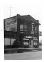
| Description: | An exterior view of Trameri's Bar at 625 West Main Street. |

| Date: | 1974 |
|---|---|
| Description: | This map shows streets, businesses and parks. The Yellow River is labeled. The Plat shows saw mills and land owned by D.R.W. Williams, Wm. Williams, and Jo... |
| Date: | 1974 |
|---|---|
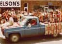
| Description: | Stuart (husband of Frances Decorah) driving a truck in a street parade. The truck is draped with blankets displaying a Native American motif. A woman in tr... |
If you didn't find the material you searched for, our Library Reference Staff can help.
Call our reference desk at 608-264-6535 or email us at: