 Filter: Categories of Wisconsin Historical Images
Filter: FULL_DATE of 1974
Filter: Subject of service industries
Filter: Categories of Wisconsin Historical Images
Filter: FULL_DATE of 1974
Filter: Subject of service industries
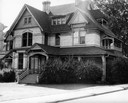
| Date: | 1974 |
|---|---|
| Description: | "Hearthstone," a house built in 1880-1882 by paper mill owner Henry J. Rogers, was the first residence electrified from a centrally located hydroelectric p... |

| Date: | 1974 |
|---|---|
| Description: | This 1968 map identifies resorts in the Lac du Flambeau Indian Reservation region of Wisconsin, covering parts of Iron, Vilas, Oneida, and Price counties. ... |

| Date: | 1974 |
|---|---|
| Description: | This map shows roads, highways, railroads, major arterials, towns, parks, recreational areas, and parts of Fox River and bay of Green Bay. The map includes... |

| Date: | 1974 |
|---|---|
| Description: | Front page and sandwich pages from the hand-lettered, multi-page Ella's Deli menu. Other pages include open-face platters, jumbo deli platters, fish and sa... |
| Date: | 1974 |
|---|---|
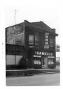
| Description: | An exterior view of Trameri's Bar at 625 West Main Street. |
| Date: | 1974 |
|---|---|
| Description: | This blue line map show gas services and county boundaries. Includes a legend of company names in lower left hand corner. |

| Date: | 1974 |
|---|---|
| Description: | Text on front reads: Holiday Inn & Solardome, Stevens Point, Wisconsin." On reverse: "Holiday Inn & Solardome of Stevens Point. U.S. 51 & N. Point Drive. S... |
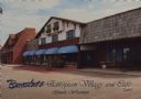
| Date: | 1974 |
|---|---|
| Description: | Text on front reads: "Burnstadt's European Village and Cafe, Tomah, Wisconsin." On reverse: "Burnstadt's European Village and Cafe. The warmth of European ... |
If you didn't find the material you searched for, our Library Reference Staff can help.
Call our reference desk at 608-264-6535 or email us at: