 Filter: Categories of Wisconsin Historical Images
Filter: FULL_DATE of 1974
Filter: Subject of indians of north america
Filter: Categories of Wisconsin Historical Images
Filter: FULL_DATE of 1974
Filter: Subject of indians of north america

| Date: | 1974 |
|---|---|
| Description: | This 1968 map identifies resorts in the Lac du Flambeau Indian Reservation region of Wisconsin, covering parts of Iron, Vilas, Oneida, and Price counties. ... |

| Date: | 1974 |
|---|---|
| Description: | Map of Wisconsin with drawings illustrating historic places and events throughout the state. The Great Seal of the State of Wisconsin appears at the top ri... |

| Date: | 1974 |
|---|---|
| Description: | This map draws content from a map originally created by George Featherstongaugh in 1840. The map shows streets, land ownership, the Brotherton Indian reser... |

| Date: | 1974 |
|---|---|
| Description: | Doris Emery addressing the Tribal Council. She spent many years in Tribal Politics and held various positions; Councilperson (12 years), First Tribal Judge... |
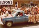
| Date: | 1974 |
|---|---|
| Description: | Stuart (husband of Frances Decorah) driving a truck in a street parade. The truck is draped with blankets displaying a Native American motif. A woman in tr... |
If you didn't find the material you searched for, our Library Reference Staff can help.
Call our reference desk at 608-264-6535 or email us at: