 Filter: Categories of Wisconsin Historical Images
Filter: FULL_DATE of 1974
Filter: Subject of human settlements
Filter: Categories of Wisconsin Historical Images
Filter: FULL_DATE of 1974
Filter: Subject of human settlements

| Date: | 1974 |
|---|---|
| Description: | This map shows streets, businesses and parks. The Yellow River is labeled. The Plat shows saw mills and land owned by D.R.W. Williams, Wm. Williams, and Jo... |

| Date: | 1974 |
|---|---|
| Description: | This map draws content from a map originally created by George Featherstongaugh in 1840. The map shows streets, land ownership, the Brotherton Indian reser... |

| Date: | 1974 |
|---|---|
| Description: | Black watercolor of a single-story store with large wood-framed, plate-glass windows, a false front and a pitched roof. The building's external side wall b... |
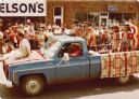
| Date: | 1974 |
|---|---|
| Description: | Stuart (husband of Frances Decorah) driving a truck in a street parade. The truck is draped with blankets displaying a Native American motif. A woman in tr... |

| Date: | 1974 |
|---|---|
| Description: | View across State Street towards the Capitol Theater, designed in a Spanish colonial style and highly decorative, including arched windows above the marque... |

| Date: | 1974 |
|---|---|
| Description: | Two girls are rolling about in the street on small, foot-powered, six-wheeled ATV toys, and a man is standing on the corner next to a building with a billb... |

| Date: | 1974 |
|---|---|
| Description: | Two railroad workers are pulling on a chain next to a railroad car carrying coal. |
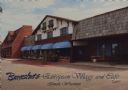
| Date: | 1974 |
|---|---|
| Description: | Text on front reads: "Burnstadt's European Village and Cafe, Tomah, Wisconsin." On reverse: "Burnstadt's European Village and Cafe. The warmth of European ... |
If you didn't find the material you searched for, our Library Reference Staff can help.
Call our reference desk at 608-264-6535 or email us at: