 Filter: Categories of Wisconsin Historical Images
Filter: FULL_DATE of 1974
Filter: Subject of cities and towns
Filter: Subject of roads
Filter: Categories of Wisconsin Historical Images
Filter: FULL_DATE of 1974
Filter: Subject of cities and towns
Filter: Subject of roads
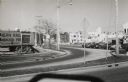
| Date: | 1974 |
|---|---|
| Description: | View of the busy intersection at Regent Steet and West Washington Avenue. |
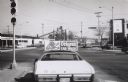
| Date: | 1974 |
|---|---|
| Description: | Intersection at Regent Street and West Washington Avenue. An Octopus Car Wash sign is mounted on top of car in the foreground. |

| Date: | 1974 |
|---|---|
| Description: | A view of University Avenue near the intersection of Park Street looking south towards the storefronts of Campus Camera at 827 University Avenue and Choles... |
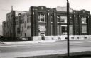
| Date: | 1974 |
|---|---|
| Description: | An exterior view of the Kennedy Dairy Company, which was built in 1910 and located at 621-629 West Washington Avenue. A sign above a doorway on the left si... |
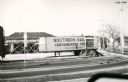
| Date: | 1974 |
|---|---|
| Description: | The remains of an ice rack used for refrigerated freight cars, located at the railroad yards on Regent Street and West Washington Avenue. |
| Date: | 1974 |
|---|---|
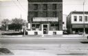
| Description: | View of 615 West Washington Avenue, at the time of photograph, Wisconsin Felton Sporting Goods store. The adjacent lot once housed the Illinois Central pas... |

| Date: | 1974 |
|---|---|
| Description: | View looking southeast from the State Historical Society of Wisconsin toward the University Club, the Pres House, and dormitories in the far background. |
| Date: | 1974 |
|---|---|
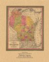
| Description: | A map that was originally published around 1851 in S. Augustus Mitchell's New universal atlas, shows portions of present-day Iron and Vilas counties north ... |

| Date: | 1974 |
|---|---|
| Description: | This 1974 map is a reproduction of the original survey maps of the Four Lakes region of Dane County, Wisconsin. It shows sections, lakes, rivers, wetlands,... |

| Date: | 1974 |
|---|---|
| Description: | This map shows roads, highways, railroads, major arterials, towns, parks, recreational areas, and parts of Fox River and bay of Green Bay. The map includes... |

| Date: | 1974 |
|---|---|
| Description: | This map includes a diagram on the bottom left margin showing civil towns, a township numbering system, state highways, roads, lakes, and a legend on the r... |
If you didn't find the material you searched for, our Library Reference Staff can help.
Call our reference desk at 608-264-6535 or email us at: