 Filter: Categories of Wisconsin Historical Images
Filter: FULL_DATE of 1973
Filter: Subject of land
Filter: Categories of Wisconsin Historical Images
Filter: FULL_DATE of 1973
Filter: Subject of land
| Date: | 1973 |
|---|---|
| Description: | Exterior of public school building, with a slide and trees. |

| Date: | 1973 |
|---|---|
| Description: | Buildings near International Harvester's Saltillo Works in Mexico. A donkey stands at left, and a tractor is parked in front of a building near a large, st... |

| Date: | 1973 |
|---|---|
| Description: | "The Twin Towers of Lower Manhattan stand majestic as a tour boat goes by." |

| Date: | 1973 |
|---|---|
| Description: | Map shows sections, trails, roads, and locations of ancient burial grounds, hills, groves, and settlers. Printed in brown ink. |

| Date: | 1973 |
|---|---|
| Description: | An International Scout hauling a camper is parked next to a body of water. A man is fishing while a woman looks on from the banks of the water. |

| Date: | 1973 |
|---|---|
| Description: | View towards lake and mountain with an International Scout hauling a camper parked next to the shoreline. A man, woman, and three children are gathered beh... |

| Date: | 1973 |
|---|---|
| Description: | This map is a photocopy of the original plat of Beloit from 1838. The map shows labeled roads, lots, and rivers. |
| Date: | 1973 |
|---|---|
| Description: | This standard U.S.G.S. topographic map was annotated by civil engineer and railroad historian James P. Kaysen to show the location of existing and defunct ... |

| Date: | 1973 |
|---|---|
| Description: | This map includes an index of streets and schools and also shows parks, schools and public lands, and industrial sites. Portions of the map are in green an... |

| Date: | 1973 |
|---|---|
| Description: | This map shows the uses of land in St. Croix County. Uses are indicated by colored dots. Residential(Yellow), Commercial(Red), Industrial(Grey), Parks and ... |

| Date: | 1973 |
|---|---|
| Description: | This map is 1 of 7 and includes a location map and township diagram in the margins. The map includes a key of land type: Residential (yellow), Commercial (... |

| Date: | 1973 |
|---|---|
| Description: | This map is 2 of 7 and includes a location map and township diagram in the bottom margin. The map includes a key of land type: Residential (yellow), Commer... |

| Date: | 1973 |
|---|---|
| Description: | This map is 3 of 7 and includes a location map and township diagram in the margins. The map includes a key of land type: Residential (yellow), Commercial (... |

| Date: | 1973 |
|---|---|
| Description: | This map is 4 of 7 and includes a location map and township diagram in the left margin. The map includes a key of land type: Residential (yellow), Commerci... |

| Date: | 1973 |
|---|---|
| Description: | This map is 5 of 7 and includes a location map and township diagram in the left margin. The map includes a key of land type: Residential (yellow), Commerci... |

| Date: | 1973 |
|---|---|
| Description: | This map is 6 of 7 and includes a location map and township diagram in the bottom margin. The map includes a key of land type: Residential (yellow), Commer... |

| Date: | 1973 |
|---|---|
| Description: | This map is 7 of 7 and includes a location map and township diagram in the left margin. The map includes a key of land type: Residential (yellow), Commerci... |

| Date: | 1973 |
|---|---|
| Description: | Three-quarter view from front left of a man sitting in the driver's seat of a 100 Travelall parked in a field. The Travelall exterior is yellow with woodgr... |
| Date: | 1973 |
|---|---|
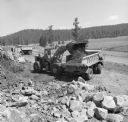
| Description: | Elevated view of a man operating a Hough Pay Loader to load material into a 350 Pay Hauler. In the background is another Pay Hauler. Morrison-Knudsen Co., ... |
| Date: | 1973 |
|---|---|
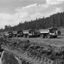
| Description: | Four 350 Pay Haulers lined up in a row. There is a tanker truck parked on the left. Morrison-Knudsen Co., Inc. and Gordon H. Ball, Inc., a joint venture ha... |
If you didn't find the material you searched for, our Library Reference Staff can help.
Call our reference desk at 608-264-6535 or email us at: