Filter: Categories of Wisconsin Historical Images
Filter: FULL_DATE of 1973
Filter: Subject of human settlements
Filter: Categories of Wisconsin Historical Images
Filter: FULL_DATE of 1973
Filter: Subject of human settlements

| Date: | 1973 |
|---|---|
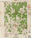
| Description: | This map is a photocopy of the original plat of Beloit from 1838. The map shows labeled roads, lots, and rivers. |

| Date: | 1973 |
|---|---|
| Description: | This map includes an index of streets and schools and also shows parks, schools and public lands, and industrial sites. Portions of the map are in green an... |

| Date: | 1973 |
|---|---|
| Description: | This map shows the uses of land in St. Croix County. Uses are indicated by colored dots. Residential(Yellow), Commercial(Red), Industrial(Grey), Parks and ... |

| Date: | 1973 |
|---|---|
| Description: | This map is 1 of 7 and includes a location map and township diagram in the margins. The map includes a key of land type: Residential (yellow), Commercial (... |

| Date: | 1973 |
|---|---|
| Description: | This map is 2 of 7 and includes a location map and township diagram in the bottom margin. The map includes a key of land type: Residential (yellow), Commer... |

| Date: | 1973 |
|---|---|
| Description: | This map is 3 of 7 and includes a location map and township diagram in the margins. The map includes a key of land type: Residential (yellow), Commercial (... |

| Date: | 1973 |
|---|---|
| Description: | This map is 4 of 7 and includes a location map and township diagram in the left margin. The map includes a key of land type: Residential (yellow), Commerci... |

| Date: | 1973 |
|---|---|
| Description: | This map is 5 of 7 and includes a location map and township diagram in the left margin. The map includes a key of land type: Residential (yellow), Commerci... |

| Date: | 1973 |
|---|---|
| Description: | This map is 6 of 7 and includes a location map and township diagram in the bottom margin. The map includes a key of land type: Residential (yellow), Commer... |

| Date: | 1973 |
|---|---|
| Description: | This map is 7 of 7 and includes a location map and township diagram in the left margin. The map includes a key of land type: Residential (yellow), Commerci... |

| Date: | 1973 |
|---|---|
| Description: | Three-quarter view from front right of a man sitting in the driver's seat of a 100 Special Pickup. The truck is parked outdoors in a parking area with a br... |

| Date: | 1973 |
|---|---|
| Description: | This colored map displays Wisconsin and bordering areas of Iowa, Minnesota, and Michigan. There is color-coding on the map to indicate National Forests, a... |

| Date: | 1973 |
|---|---|
| Description: | Musicians in the foreground are performing before a crowd at a Hispanic Community concert in Milwaukee. |

| Date: | 1973 |
|---|---|
| Description: | View towards the shoreline of a river, with three boys sitting on the bank in the foreground. There is a building among trees on the opposite shoreline. An... |
| Date: | 1973 |
|---|---|
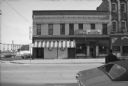
| Description: | View across East Main Street towards the PBC, which has an entrance on the corner on the left, at East Main and Webster Streets. The entrance to the Dome R... |
| Date: | 1973 |
|---|---|
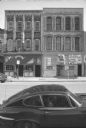
| Description: | View across East Main Street towards two buildings. The building on the left has a sign above the entrance for The Dangle: All American Burlesque. The buil... |
| Date: | 1973 |
|---|---|
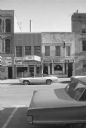
| Description: | View across East Main Street towards commercial buildings with businesses on the ground floors, including This is Heaven Sauna Massage, Econo Print, Qualif... |
If you didn't find the material you searched for, our Library Reference Staff can help.
Call our reference desk at 608-264-6535 or email us at: