 Filter: Categories of Wisconsin Historical Images
Filter: FULL_DATE of 1971
Filter: Subject of rivers
Filter: Categories of Wisconsin Historical Images
Filter: FULL_DATE of 1971
Filter: Subject of rivers
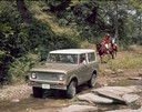
| Date: | 1971 |
|---|---|
| Description: | Color advertising photograph of a couple in a 1971 International Scout pickup crossing a small creek, as another couple is following behind on horseback. |
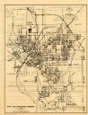
| Date: | 1971 |
|---|---|
| Description: | This map of Stevens Point shows labeled streets and selected points of interest: "Holiday Inn," "Westernberger's Gifts," "Ralph L. Banke MLS Realtor," "Gol... |

| Date: | 1971 |
|---|---|
| Description: | A topgraphical map of Cable, Wisconsin showing railroads. |

| Date: | 1971 |
|---|---|
| Description: | A topographical map of Namekagon Lake and the surrounding area. |
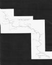
| Date: | 1971 |
|---|---|
| Description: | This map shows major tributaries, and also covers parts of Marathon and Portage Counties. |
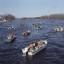
| Date: | 1971 |
|---|---|
| Description: | Elevated view of many groups of people sitting in motorboats fishing on the Wolf River. |

| Date: | 1971 |
|---|---|
| Description: | A topographical map of the Grand View NW quadrangle. |
If you didn't find the material you searched for, our Library Reference Staff can help.
Call our reference desk at 608-264-6535 or email us at:
