 Filter: Categories of Wisconsin Historical Images
Filter: FULL_DATE of 1971
Filter: Subject of lakes
Filter: Categories of Wisconsin Historical Images
Filter: FULL_DATE of 1971
Filter: Subject of lakes

| Date: | 1971 |
|---|---|
| Description: | Color advertising photograph of a family singing by a campfire near a Travelall 1010 truck and a Mallard camper. A man is in the foreground chopping wood f... |

| Date: | 1971 |
|---|---|
| Description: | A topgraphical map of Cable, Wisconsin showing railroads. |

| Date: | 1971 |
|---|---|
| Description: | A topographical map of Namekagon Lake and the surrounding area. |

| Date: | 1971 |
|---|---|
| Description: | This map shows streets, highways, railroads, parks, colleges, cemeteries, county clubs, University of Wisconsin, Truax Field, Middleton, Shorewood Hills, M... |
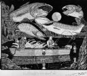
| Date: | 1971 |
|---|---|
| Description: | Elaborate pen-and-ink drawing of two fisherman at night sitting in a small motorboat (named PAM) on a lake. Large trout are looming over their heads with a... |

| Date: | 1971 |
|---|---|
| Description: | Two young women are competing in logrolling. People watch from bleachers on a lawn in the background. One person is sitting and watching from a rowboat, an... |

| Date: | 1971 |
|---|---|
| Description: | A topographical map of the Grand View NW quadrangle. |
If you didn't find the material you searched for, our Library Reference Staff can help.
Call our reference desk at 608-264-6535 or email us at:

