 Filter: Categories of Wisconsin Historical Images
Filter: FULL_DATE of 1971
Filter: Subject of forests and forestry
Filter: Categories of Wisconsin Historical Images
Filter: FULL_DATE of 1971
Filter: Subject of forests and forestry

| Date: | 1971 |
|---|---|
| Description: | A topgraphical map of Cable, Wisconsin showing railroads. |

| Date: | 1971 |
|---|---|
| Description: | A topographical map of Namekagon Lake and the surrounding area. |

| Date: | 1971 |
|---|---|
| Description: | A topographical map of the Grand View NW quadrangle. |
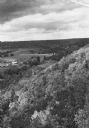
| Date: | 1971 |
|---|---|
| Description: | Elevated view along a forested hillside, overlooking farm fields, a barn, and a small town in the distance. |
If you didn't find the material you searched for, our Library Reference Staff can help.
Call our reference desk at 608-264-6535 or email us at:
