 Filter: Categories of Wisconsin Historical Images
Filter: FULL_DATE of 1970
Filter: Subject of parks
Filter: Creator Name of Unknown
Filter: Categories of Wisconsin Historical Images
Filter: FULL_DATE of 1970
Filter: Subject of parks
Filter: Creator Name of Unknown
| Date: | 1970 |
|---|---|
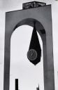
| Description: | Close-up of the clock in the tower in the Milwaukee Civic Center Plaza. The clock hangs from the inside roof of the three-legged tower in a teardrop-shape... |
| Date: | 1970 |
|---|---|
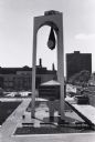
| Description: | Elevated view of Milwaukee Civic Center Plaza. Entire clock tower is visible, with the plaza around the base, and other buildings in the background. The c... |

| Date: | 1970 |
|---|---|
| Description: | A map of parks of Kewaunee County, Wisconsin, showing the fishing spots, lakes and parks in the area, it also provides a location map of the area. On the ... |

| Date: | 1970 |
|---|---|
| Description: | Color coded map. Legend in the top left hand corner reads: "EXISTING AIRPORT PAVEMENT" (purple), "FUTURE 5-YEAR DEVELOPMENT" (bright pink), "ULTIMATE AIRPO... |

| Date: | 1970 |
|---|---|
| Description: | This map shows roads, parks, swimming beaches, golf courses, yacht harbors, light houses, airports, public hunting grounds, waysides, schools, and fishing ... |
If you didn't find the material you searched for, our Library Reference Staff can help.
Call our reference desk at 608-264-6535 or email us at: