 Filter: Categories of Wisconsin Historical Images
Filter: FULL_DATE of 1970
Filter: Subject of land use
Filter: Type of Map or Atlas
Filter: Categories of Wisconsin Historical Images
Filter: FULL_DATE of 1970
Filter: Subject of land use
Filter: Type of Map or Atlas

| Date: | 1970 |
|---|---|
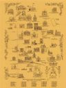
| Description: | This pictorial map of Dunn County, Wisconsin, from the 1970s depicts historical events that occurred in the county. It shows cemeteries, churches, schools,... |
| Date: | 1970 |
|---|---|
| Description: | This pictorial map shows illustrations of historical landmarks and events, some of which include the fairgrounds, churches, the courthouse, Turner Opera Ho... |

| Date: | 1970 |
|---|---|
| Description: | This map shows colored-coded land use with a legend in the bottom margin. Land classifications include: Year-round Residential (yellow), Seasonal Residenti... |

| Date: | 1970 |
|---|---|
| Description: | This photocopy map shows the locations of historic buildings, as well as all other buildings in the isthmus. The map also includes photographs of selected ... |
If you didn't find the material you searched for, our Library Reference Staff can help.
Call our reference desk at 608-264-6535 or email us at: