 Filter: Categories of Wisconsin Historical Images
Filter: FULL_DATE of 1970
Filter: Subject of cemeteries
Filter: Categories of Wisconsin Historical Images
Filter: FULL_DATE of 1970
Filter: Subject of cemeteries
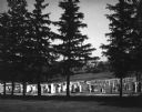
| Date: | 1970 |
|---|---|
| Description: | A country cemetery with a row of pine trees in the foreground. In the far distance is a farm. |

| Date: | 1970 |
|---|---|
| Description: | This pictorial map of Dunn County, Wisconsin, from the 1970s depicts historical events that occurred in the county. It shows cemeteries, churches, schools,... |

| Date: | 1970 |
|---|---|
| Description: | This map shows lot and block numbers, city limits, cemeteries, schools, outdoor theater, Lumberjack Bowl, and Historyland among other attractions. |

| Date: | 1970 |
|---|---|
| Description: | This map shows lots, house numbers, institutional buildings, and cemeteries. The bottom of the map includes indexes to streets, points of interest and inst... |
If you didn't find the material you searched for, our Library Reference Staff can help.
Call our reference desk at 608-264-6535 or email us at: