Filter: Categories of Wisconsin Historical Images
Filter: FULL_DATE of 1969
Filter: Subject of water
Filter: Categories of Wisconsin Historical Images
Filter: FULL_DATE of 1969
Filter: Subject of water

| Date: | 1969 |
|---|---|
| Description: | Cover for the 1969 Wisconsin Friends of Our Native Landscape program. Depicted is a tree with white blossoms, yellow flowers, and a pathway leading up to a... |

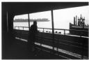
| Date: | 1969 |
|---|---|
| Description: | The Island's Edge, Williamsburg Bridge, East River. |

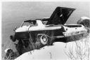
| Date: | 1969 |
|---|---|
| Description: | A large puddle in a parking lot where two automobiles, a Corvair and a Volkswagen, are parked. |

| Date: | 1969 |
|---|---|
| Description: | Elevated view of State Street looking east towards the Wisconsin State Capitol. |
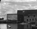
| Date: | 1969 |
|---|---|
| Description: | View from water of the sides of three wharf buildings in a bay of Lake Superior. |
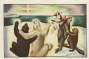
| Date: | 1969 |
|---|---|
| Description: | Holiday card with three couples of animals dancing; two bears, a seal and a beaver, a fox and a rabbit. They are on a snowbank overlooking the sea with the... |

| Date: | 1969 |
|---|---|
| Description: | This Post Office Department map identifies post offices, summer post offices, rural stations, highway post offices, Post Office sectional centers, rural de... |

| Date: | 1969 |
|---|---|
| Description: | A map of the Elroy-Sparta State Trail and the surrounding area, showing the townships, the towns of Cashton, Sparta, in the west, and Union Center and Elro... |

| Date: | 1969 |
|---|---|
| Description: | Map showing St. Croix Falls and Taylors Falls, Minnesota. The map was produced by the St. Croix Falls Chamber of Commerce and Taylor Falls Commercial Club.... |

| Date: | 1969 |
|---|---|
| Description: | Elevated view of a tent and canoe in the woods by a lake. |

| Date: | 1969 |
|---|---|
| Description: | This street map was given out by Mound City Bank and features a legend of points of interest and a street index. Streets are labeled as is the Roundtree Br... |

| Date: | 1969 |
|---|---|
| Description: | This map is pen and ink on paper and shows the location of churches, local streets, railroads, parks, Middleton, Shorewood Hills, Monona, Maple Bluff, McFa... |

| Date: | 1969 |
|---|---|
| Description: | A view from near the main house at Black Point Estate shows the brick drive and walk in the foreground. Geneva Lake is seen in the background, framed by a... |

| Date: | 1969 |
|---|---|
| Description: | This map shows ghost towns, Indian reservations, lakes, railroads, and rivers. Ghost towns are numbered and listed in a corresponding index. |

| Date: | 1969 |
|---|---|
| Description: | This map shows ski areas, resorts, camps, special areas, airports, and roads. The map covers Vilas and Oneida counties and parts of Iron, Price, Lincoln, L... |

| Date: | 1969 |
|---|---|
| Description: | This map shows businesses, resorts, roads, public boat landings, schools, cemeteries, and location of fish and game. An inset map reads: Continuation along... |

| Date: | 1969 |
|---|---|
| Description: | Imaginative pen-and-ink drawing of a cricket or grasshopper serenading a large trout swimming underwater. The insect is playing a violin, while standing on... |

| Date: | 1969 |
|---|---|
| Description: | Portrait of a young boy in front of a lake holding up and examining a crayfish. |
If you didn't find the material you searched for, our Library Reference Staff can help.
Call our reference desk at 608-264-6535 or email us at: