 Filter: Categories of Wisconsin Historical Images
Filter: FULL_DATE of 1969
Filter: Subject of lakes
Filter: Categories of Wisconsin Historical Images
Filter: FULL_DATE of 1969
Filter: Subject of lakes

| Date: | 1969 |
|---|---|
| Description: | Cover for the 1969 Wisconsin Friends of Our Native Landscape program. Depicted is a tree with white blossoms, yellow flowers, and a pathway leading up to a... |

| Date: | 1969 |
|---|---|
| Description: | Elevated view of State Street looking east towards the Wisconsin State Capitol. |

| Date: | 1969 |
|---|---|
| Description: | This Post Office Department map identifies post offices, summer post offices, rural stations, highway post offices, Post Office sectional centers, rural de... |
| Date: | 1969 |
|---|---|
| Description: | Elevated view of a tent and canoe in the woods by a lake. |

| Date: | 1969 |
|---|---|
| Description: | This map is pen and ink on paper and shows the location of churches, local streets, railroads, parks, Middleton, Shorewood Hills, Monona, Maple Bluff, McFa... |
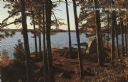
| Date: | 1969 |
|---|---|
| Description: | A view from near the main house at Black Point Estate shows the brick drive and walk in the foreground. Geneva Lake is seen in the background, framed by a... |

| Date: | 1969 |
|---|---|
| Description: | This map shows ghost towns, Indian reservations, lakes, railroads, and rivers. Ghost towns are numbered and listed in a corresponding index. |

| Date: | 1969 |
|---|---|
| Description: | This map shows ski areas, resorts, camps, special areas, airports, and roads. The map covers Vilas and Oneida counties and parts of Iron, Price, Lincoln, L... |

| Date: | 1969 |
|---|---|
| Description: | This map shows businesses, resorts, roads, public boat landings, schools, cemeteries, and location of fish and game. An inset map reads: Continuation along... |

| Date: | 1969 |
|---|---|
| Description: | Portrait of a young boy in front of a lake holding up and examining a crayfish. |

| Date: | 1969 |
|---|---|
| Description: | Two men in a canoe on a lake. One man is pulling a muskellunge (musky) out of the water with his fishing pole. The other man is standing and holding a net ... |

| Date: | 1969 |
|---|---|
| Description: | Two men in a canoe on a lake, with one of the men holding a muskellunge (musky) hooked on a fishing line, and a fishing net. The other man is holding the f... |
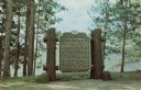
| Date: | 1969 |
|---|---|
| Description: | Historical marker on the shore of Flambeau Lake. Erected 1937. |

| Date: | 1969 |
|---|---|
| Description: | A map of Wisconsin from The Atlas of the Eight Counties of Forest, Florence, Iron, Langlade, Lincoln, Oneida, Price, Vilas. The map shows rivers and a vari... |
If you didn't find the material you searched for, our Library Reference Staff can help.
Call our reference desk at 608-264-6535 or email us at: