 Filter: Categories of Wisconsin Historical Images
Filter: FULL_DATE of 1969
Filter: Subject of indians of north america
Filter: Categories of Wisconsin Historical Images
Filter: FULL_DATE of 1969
Filter: Subject of indians of north america

| Date: | 1969 |
|---|---|
| Description: | This map shows ghost towns, Indian reservations, lakes, railroads, and rivers. Ghost towns are numbered and listed in a corresponding index. |

| Date: | 1969 |
|---|---|
| Description: | Snapshot of Mary Taylor Oiyotte standing outdoors in the snow. She is wearing a flowered dress and red sweater. Behind her is a snowbank and the windows of... |

| Date: | 1969 |
|---|---|
| Description: | Snapshot of Mary Taylor Oiyotte wearing a flowered dress and red sweater. Behind her is a snowbank and the windows of a white dwelling with red and white a... |
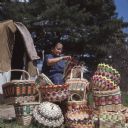
| Date: | 1969 |
|---|---|
| Description: | A Ho-Chunk woman, Mable Davis (maiden name) Lowe is sitting and weaving a basket. Behind her is a dwelling (chipoteke). Several finished woven baskets are ... |
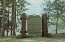
| Date: | 1969 |
|---|---|
| Description: | Historical marker on the shore of Flambeau Lake. Erected 1937. |

| Date: | 1969 |
|---|---|
| Description: | A map of Wisconsin from The Atlas of the Eight Counties of Forest, Florence, Iron, Langlade, Lincoln, Oneida, Price, Vilas. The map shows rivers and a vari... |
If you didn't find the material you searched for, our Library Reference Staff can help.
Call our reference desk at 608-264-6535 or email us at: